

If you’ve been following us this week, we’ve been harping on what appeared to be a prolonged period of above average temperatures starting this weekend and heading into the first portion of July. No less than a day after I posted about it, the model consensus has trended much cooler and back to a pattern we’ve all been too familiar with – a blocking region of high pressure in the Plains and Central Canada and a cooling trough in the East with signs of another cut-off low.
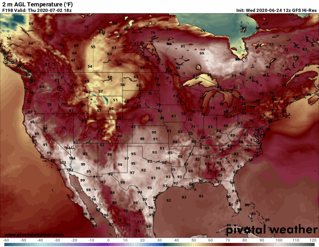
Now it’s almost July, and cut-off lows shouldn’t even been a topic of conversation this far south. But this is the year 2020, and the scientific community continues to be surprised! Last weekend, temperatures soared to over 100 degrees above the Arctic Circle in Siberia. Later next week, it could reach 100 degrees close to Hudson Bay, Northwest Ontario!
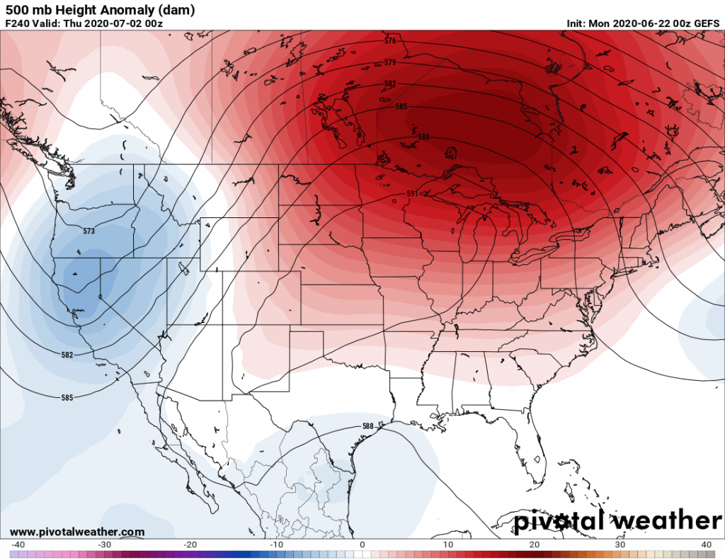
Let’s take a look at the 500 millibar model ensemble forecasts – a prediction of regions of anomalously warm or cool weather at about 18,000 feet above ground, or in the middle of the atmosphere. Late last weekend into the start of this week, the trend was for all of the heat bottled up in the Southwest and Southern Plains to expand into the Eastern U.S. and Canada, and give us some above average temperatures for a fairly good stretch of the next month. After all, record warmth has occurred in Northern New England and eastern Canada already as those spots have had more 90 degree days than we have, and trends showed that heat has to go somewhere, right?
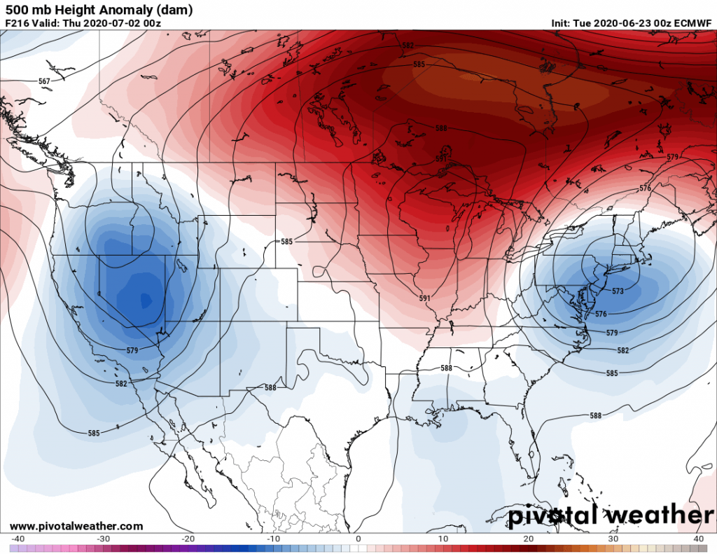
Well not so fast, my friend! A day later, maybe to spite the author, the overwhelming consensus of the models has flipped and while the extreme heat could still impact Central Canada and all the way to the Hudson Bay for the first few days of July, a trough of much cooler air dropping southwest from Atlantic Canada could cut off somewhere over the Eastern U.S. With our luck it will be over the southern Appalachians again, but I’ll explain why the models can’t be trusted.
As the Covid-19 pandemic began to unfold earlier this year, the network of observations taken from airplanes and climate and ecological data began to shut down as scientists and weather observers in critical information gathering roles were no longer able to collect data. With fewer international flights, there’s a lot less reliable data being fed into short range and medium range forecasting models over the oceans. With missing real-time data comes less accurate forecasts. So I bit and wrote the article and I won’t pin all the blame on the models, but let’s just say that forecasting skill that has improved so much over the past several years has taken a huge step back. So when the GFS model shows a tropical storm or hurricane in the Gulf in 10-12 days, I caution you, as that is coming from a forecast off a forecast, and it could end up being quite wrong. The usual hype pages could be even more inaccurate than usual.
So while it may not be piping hot for all of the Carolinas this Fourth of July, you should be able to enjoy slightly lower A/C bills than earlier predicted. And our overall summer forecast may have to trending cooler. But one thing that doesn’t look to stop from happening is a busy Atlantic hurricane season. Keep it tuned here to CWA for the latest on the July Fourth/Holiday weekend forecasts and on the evolving threats coming down the pipe this hurricane season 2020.
You must be logged in to post a comment.