
CAROLINAS 2019-2020 WINTER OUTLOOK EXTRAVAGANZA
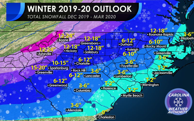
We tried out best to talk some honest numbers in our latest outlook below. Traditionally, the Coastal Plain sees overall lesser amounts that elsewhere due to the warmer ocean air. Our thinking is that most locations near the coast in the light blue will be near normal this year, with some northern locations seeing slightly above normal. Now that doesn’t mean that a freak 12″ snowstorm can’t occur. This winter anything is possible, especially with an active southern stormtrack expected.
As we head inland, the numbers jump a bit, and again these are expected season totals. It is impossible to pin down an exact number, so we are giving a range. In the navy blue we are expecting totals between 3 and 6 inches for many. Again,, freak events are possible, and one storm could dump that amount all in one sitting.
The I-85 Corridor is expected to be the most active since 2009-10 and 2013-14. Charlotte and Raleigh are expected to see 6-12″ with the immediate Raleigh area slightly less, and this includes the suburbs of both cities. For the ENTIRE area of Charlotte to receive 6 or more inches is staggering, considering 6 inches is above average, especially for South Charlotte.
Into the foothills and mountains, we are expecting well above average snowfall this season, and these are the areas that could potentially get walloped. Some mountain locations could receive record snow amounts, or at least since recent snowy winters.
OFFICIAL 2019-2020 SNOW FORECAST:
CONSIDERATIONS OF CLIMATE DATA
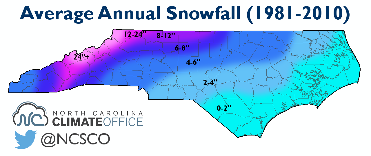
Since in our previous winter outlook article we mapped out areas according to well above average, near average, above average, or below average, we took an average snowfall map into consideration. The below is from the NC State Climate Office and shows average snow amounts from 1981-2010. We simply took this map into consideration and then adjusted for either near average, above average, or below average, and well above. The winter of 2009-2010 was busy in the western Carolinas, and the averages may have been bumped up due to this. However we also think it will be one of the snowiest winters since 2013-14, and that is not included below. That is another reason why our official map had to be adjusted.
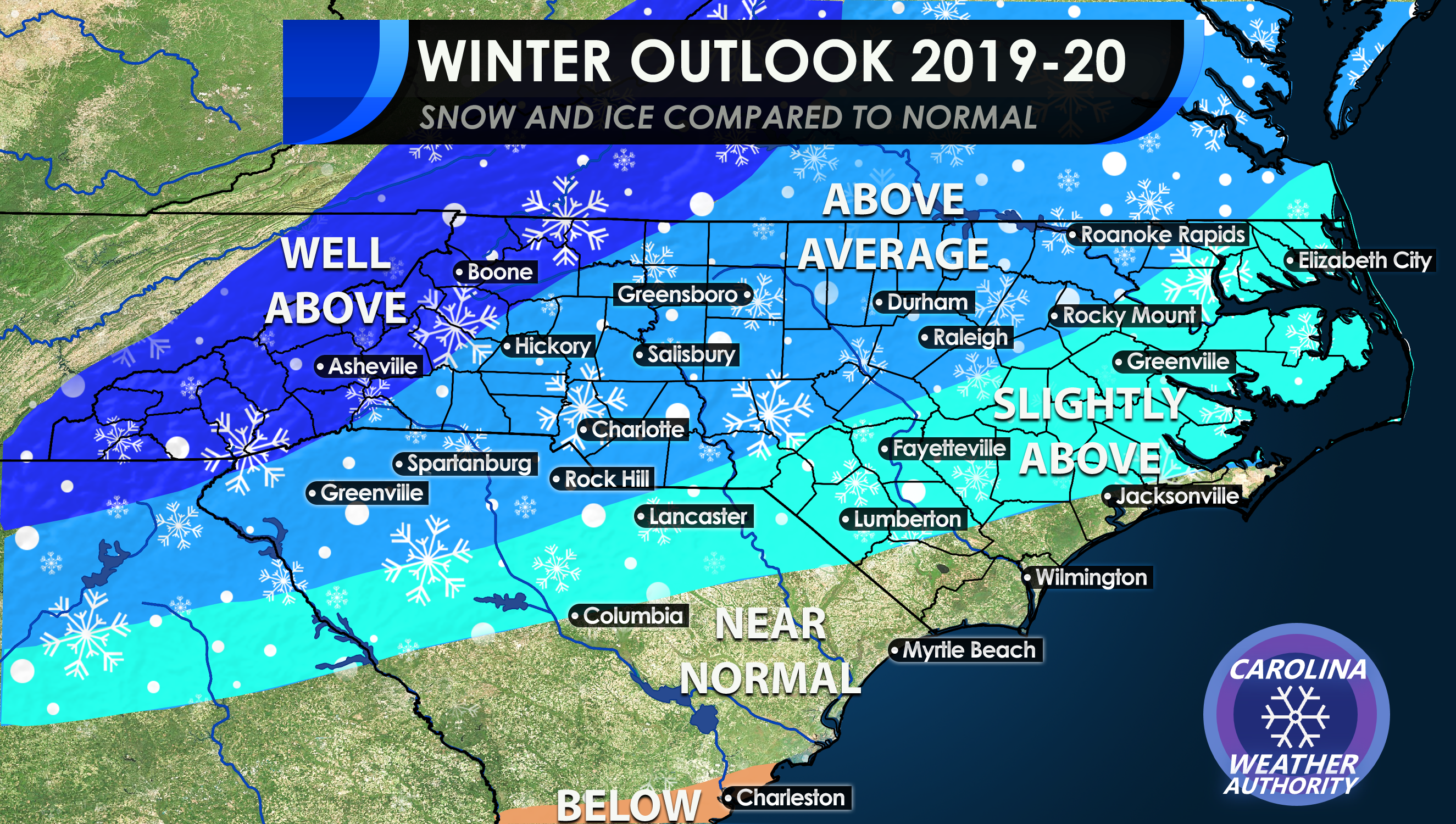
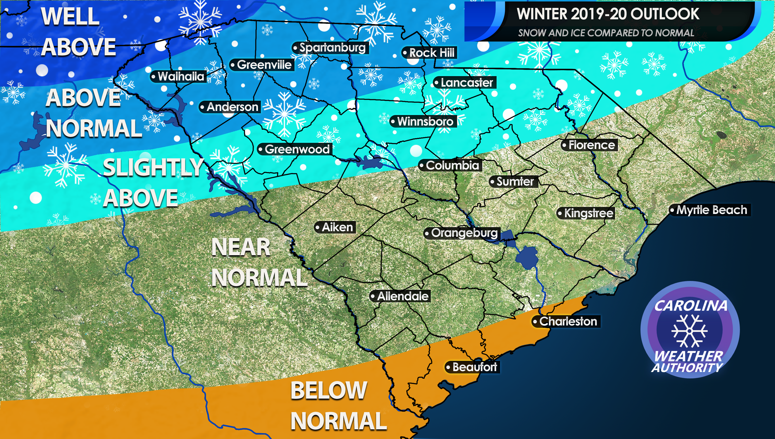
The below map was released last week and shows the overall trend expected this winter compared to normal. The mountains will be the winners, as is expected most winters. However they could see more than usual this winter. There will be a sharp cutoff from the Piedmont and to the Southeast. The Charleston area is expected to see no snow this winter, as they are expected to have below average amounts.
SOUTH CAROLINA:
OVERALL:
This season is expected to be snowy and active for the Southeast. We are expected to be in a neutral to slight El Nino pattern, which favors an active storm track. A slight El Nino could mean an above storm track for the Southeast. This is because the southern branch of the jet stream will remain active due to slight El Nino conditions, and will send storm systems across the Southeast. All that we would need would be cold air to either be in place or wrap in behind, and some of the amounts of snow could be staggering. Our snow amount outlook could in fact be conservative if there is enough cold air with an active southern storm track. In December of 2009, that snow season got started before winter officially began. We will have to keep an eye to see what skates along the southern states this year, and what comes up out of the Gulf.
We will be here to forecast amounts for each storm as they come, so stay with us!
-CWA
You must be logged in to post a comment.