
For all the cold and snow lovers who were crying foul this past winter, there’s now a “torture” pattern that has been in place which would have been perfect for the wintertime. But now, all we will get is cold and damp conditions to persist into the first week of May.
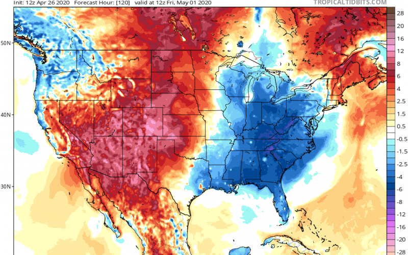
The west has been seeing some well-above normal temperatures, and even in the Desert Southwest they have been seeing some rather hot temperatures for this time of year. When there is a ridge out west, typically there is a trough in the east.
While it won’t be downright cold for us here in the Carolinas for the next week or so, it won’t exactly be warm or hot either. At times, there will be a noticeable chill in the air. The GFS takes these conditions into the month of May.
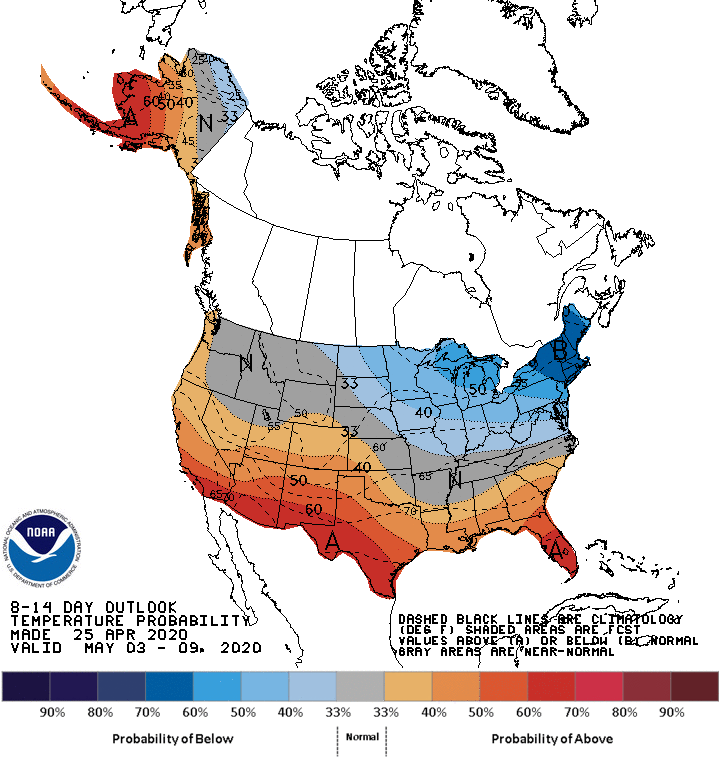
The slight chill in the air does not look to go away anytime soon, as the CPC 8-14 Day Outlook has NC near normal and still an overall trough pattern for the East Coast. The only exception is that some warmth may try to creep into the SC Lowcountry. You can find this temperature outlook plus many others on our new Models Page: Models and Observations
It could be “worse” as some of our neighbors up north are still receiving snow! This is actually kind of late in the year for this to be happening, even for them.
Keeping an eye on the accumulating snow risk Sunday night into Monday
Elevation shows up nicely in the ensemble guidance (Adirondacks, Greens, White Mountains, etc)
Fairly ridiculous for April 27th pic.twitter.com/K6BBu3LkGJ
— Eric Fisher (@ericfisher) April 24, 2020
On the bright side, it will still be to cool to go to the pool, therefore making the COVID-19 lockdown a LITTLE BIT more bearable. This is known as “gloom and doom weather” but is more reserved for northern locations. But we will still feel it here in the Carolinas.
EXCESSIVE HEAT WATCHES issued out west (including Las Vegas) next week while we close April with another surge of chilly air. May open cud be coolest here in 6 years #inwx pic.twitter.com/Gwtb7tqtr8
— Brian Wilkes (@BrianWilkes59wx) April 24, 2020
As for many locations east of the Mississippi River, the start of May this year could be the coldest in recent history. However, after a cold start to May things may start to warm up as well reach back to normal temperatures. And then we might even start to see the heat build once again.
-CWA
You must be logged in to post a comment.