
After a cool start to next week, a strong cold front is set to move into the region around Christmas Eve or early Christmas Day. Unseasonably mild air and the threat for rain and maybe thunderstorms will likely accompany the cold front, but what comes after is set to shock the region with potentially the coldest temperatures of not just this winter but of the past two winters combined!

Timing the cold front is highly uncertain, as some models having it arriving earlier Christmas Eve, while others are 12-24 hours later with it. Thus, your sometimes trusty weather app is likely to be significantly off on its forecast.

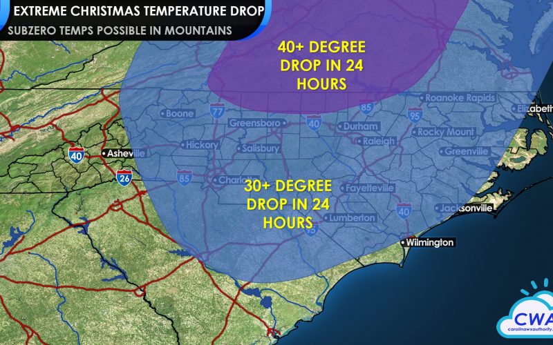
With the cold air mass to follow this front could be the coldest air in 2 winters, though there are some differences in how cold the air could be. The European model drops temperatures from the 50s and 60s into the 20s and 30s, while the GFS and Canadian models show daytime highs struggling to get out of the lower 30s next Saturday, with low temperatures perhaps in the single digits and teens west of I-95.

Official forecasts could change wildly between now and then, but know that these changes are coming!
Finally, with the cold comes perhaps our best chance at seeing a White Christmas in quite some time. December 1989 was one such memorable setup, but this one does not look to be nearly as extreme. While chances don’t look great, they are at least enough for us to mention. Forecasts will change, but ensembles show at least some possible storm tracks that leave us with a nonzero snow potential behind the front, either Friday or Friday night. Stay tuned as we look to see if that looks more possible in the coming days!

You must be logged in to post a comment.