
By Mike Griffith and Jesse Sacher
It’s that time of year, and your 2021-2022 Winter Outlook is here! While this forecast is subject to change, and we expect much variability this season, this is the most accurate info we can provide at the moment as a preliminary outlook.
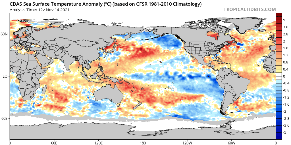
The winter of 2021-2022 will be influenced by a La Niña based in the central Pacific Ocean (below). La Niña will likely be at its strongest , possibly moderate strength in December and early January 2022 before decreasing in strength in February, possibly approaching neutral ENSO conditions by March.
La Niña tends to favor ridging along the southeast as does the negative PDO which can lead to troughing along the West Coast, which encourages the development of the southeast ridge. This is likely to happen at least occasionally during the upcoming winter, at least in the latter part of the season.
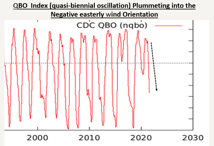
The conflicting drivers would be the fact that this La Niña is more centrally based which historically can favor colder winters in the eastern US than a typical La Niña . Additionally, with the QBO in the negative territory (below) , it is easier for blocking patterns to develop in the higher latitudes which can result in colder and stormier periods.
Another factor we like to consider is sudden stratospheric warming events, which may lead to a disruption of the polar vortex. If directed into the US can result in colder and stormier periods.
Therefore, with these factors in mind, it is likely that we will have some variability this season. The southeast ridge is likely to flex occasionally , leading to some very mild periods . We believe this is more likely later in January and into part of February according to most La Niña based analogs. The blocking patterns related to the negative phase of the QBO along with our centrally-based La Niña argues for blocking patterns to develop and lead to colder, stormier times. We believe this is likely to happen in the early part of the season with potentially some Arctic outbreaks and windows for a winter storm or two in the Carolinas.
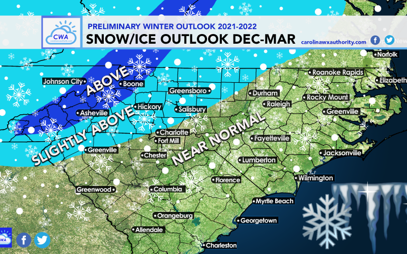
This is why we have above average snowfall in part of the Carolinas and near average in the remaining portion of the Carolinas. It only takes one storm to push most areas to near or above average, and while we don’t believe this will be a consistently snowy winter, we may still have a few windows of opportunity. Below is our *overall* snow and ice forecast for this winter:

One of our analogs is 2017-2018 in which much of the Deep South witnessed significant snowfall. The mountains are likely to see above normal snowfall due to the strong northern stream associated with La Ninas that can lead to healthy northwest flow upslope events at times, as well as potentially some larger systems. We believe mid January through mid February might be the most likely period for the southeast ridge to flex based off analogs, with colder weather perhaps returning later in February or March *IF* the La Niña and it’s influence can weaken.
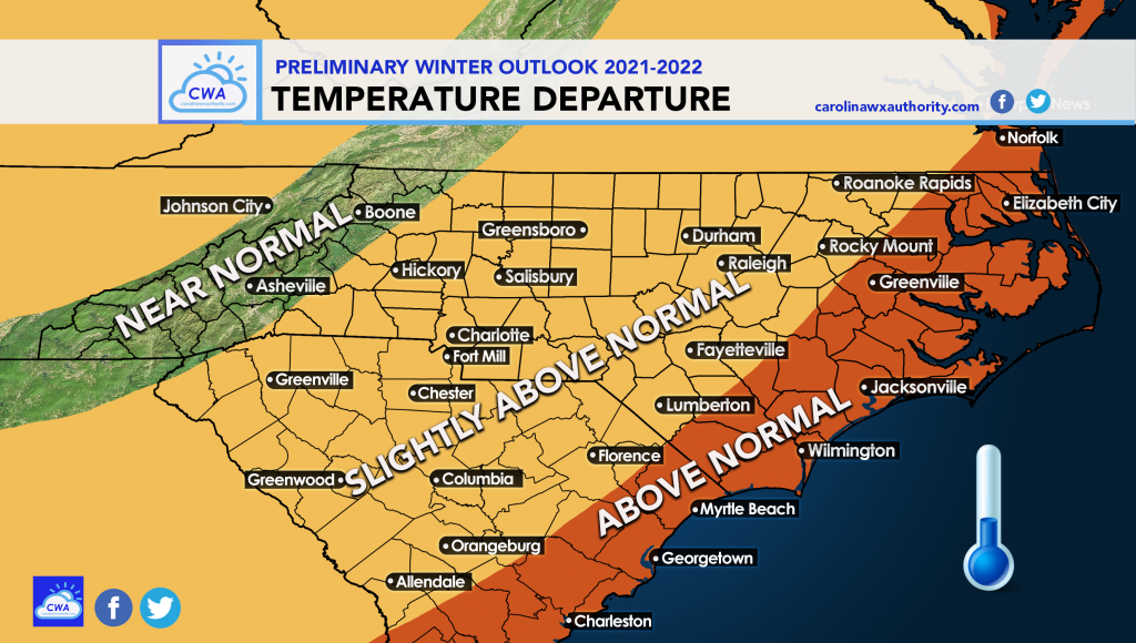
With the occasional interruption of the southeast ridge, we feel temperatures will skew above average in most of the Carolinas, but some cold outbreaks will likely offset this season from being a wall-to-wall torch. Expect a wide variety this season with a little bit for opportunity for everyone in terms of possibilities.
Below is our *overall* winter temperature forecast:
We are expecting more winter action this year than last. It will get very cold at times, snowier than normal at times. That is the caveat with this winter. We are not expecting a torch, but we are also not expecting frigid. But you don’t have to have frigid cold all winter to get some snow and ice events.
We will update this as needed as the season progresses. But for now, enjoy following us here at CWA!
Please share this article using the button below.
You must be logged in to post a comment.