
DECEMBER 2017 TEMPERATURE AND PRECIPITATION FORECAST
Many of the long-range models, including the CFSv2, had much of November in an above average temperature pattern. We saw how well that worked out. November was cold to start off, especially right after Halloween. There are some other models, including the Euro and GFS, that have not been perfect either. The reason being, when temperatures take a dive, models have a hard time latching on to such extremes. Therefore, the CFSv2 is not king and does not show much certainty when predicting temperature (or precip) in the long-range. The other ensembles may have a better idea than does a single model. That being said, the GEFS paints a much colder picture for the end of November than the single lone GFS itself. Even the ensembles may have to be taken with a grain of salt in the long-range. This is where general forecasting and analogs come into play. What has happened before in these types of pattern? What season was it or what time of the year? All this is taken into account rather than a lone variable model run.
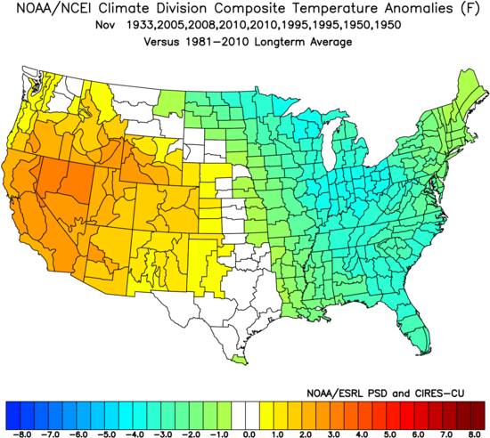
November felt like it was below average so far, in the first 16 days. The analogs from last month gave a hint to what the pattern would be for November. Below normal for much of the East.
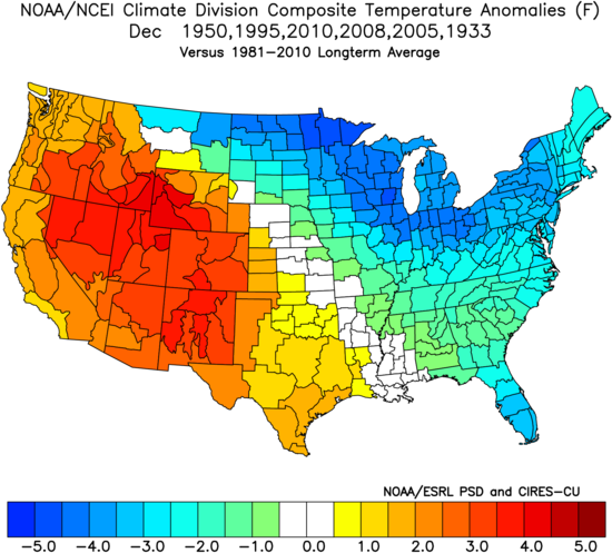
We made a map for December and what it was like for some of those previous years just like above. And what did we see? Even much more below normal temperatures. Now, this may or may not translate into more snow that usual. For now, I am thinking it will be mainly cold, especially with the increasing snowpack that was not so prevalent last year.
I changed the one year to 2003, since that was a very cold year and I see some similarities with the pattern. Without any moisture source, it was mainly just cold for many that year. Similarly to this year, it’s cold, but there is not much of a subtropical jet to bring a steady moisture source. This may or may not have an influence on this winter. The subtropical jet may get going at some point in late December.
Here is the anomaly for December using the exact same years as the first image. The take-away from this is that it was still cold. There were not signs of a “blowtorch” in the East. Upper Midwest to Maine to Florida were all below average.
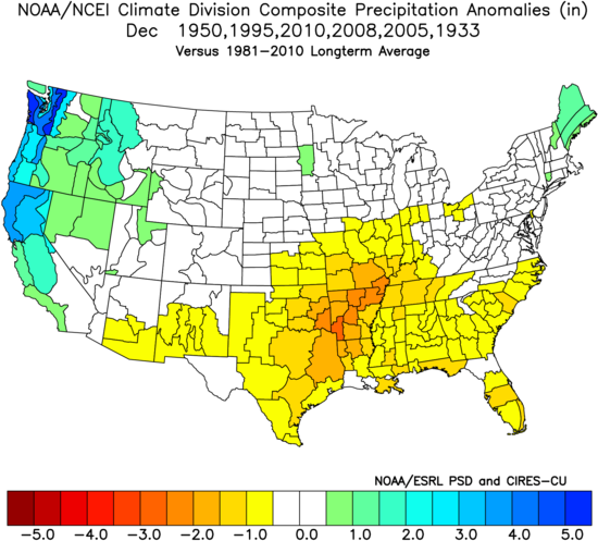
Here is the precipitation anomalies that I was talking about. Below normal also. Which translates to cold and dry. Again, the same years were used. This tells me that there will not be a bunch of east coast storms to work with. Any snow that moves through would be Clipper systems skating across the Northeast. There could be a bit more precip wise for the Northeast than indicated. This would be due to repeated shots of cold air and quick-hitting systems that drop rain and wintry precip.
Southeast remains below normal precip-wise! This does NOT mean warm.
If you haven’t already, be sure to Like us on Facebook and Share using the buttons below!
-Mike G.
You must be logged in to post a comment.