
EAST COAST WEATHER AUTHORITY | EXCLUSIVE WINTER OUTLOOK 2018-2019
Meteorologists Alexander Bielfeld, Benjamin Charles, Mike Griffith
Well, here it is. Our winter outlook is finally out. We have comprised this forecast with many different features that we have been monitoring since the end of last winter! We have compared this year a lot with 2002 and rightfully so as that year has been the mirror image of the many climate drivers that will steer our winter.
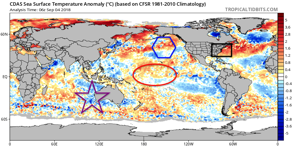
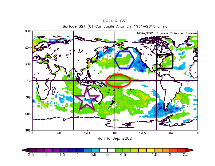
The above images are the sea surface temperatures as of the beginning of September this year, and the sea surface temperatures from January 2002 through September 2002. We outlined many similarities with the various shapes, each outlined region will play a major role in what we will see this winter.
The black rectangle off the East Coast in both images is emphasizing warmer than average sea surface temperatures. Those warmer than average temperatures will create rising air off the East Coast causing a trough to build and persist throughout the winter. Also, with the thermal gradient between the cold continent and the warmer than average sea surface temperatures will allow a more than active storm track along the East Coast.
Our main driver known as ENSO, and part of the region is outlined in the red oval. That region is outlined because we are headed into a weak to moderate El Nino for this winter. This aspect is important because what that does is it will allow for convection to bubble up in that region and keep the Madden-Jullian Oscillation (MJO) in the colder phases for the Eastern US.
Another factor that will keep MJO in the colder phases is the colder water of the western side of Australia. This will cause sinking air in that region which will then cause greater pressure differences between the El Nino region and Australia ensuring MJO stays in the colder phases.
Finally, the warmer water to the south of Alaska will in turn cause rising motion in that region causing a persistent trough to form, which then in turn down stream will cause a ridge in the Western US. That ridge in the west will then in turn cause roughing in the Eastern US.

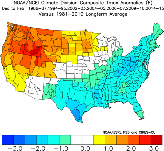
We did two reanalysis data studies, one with weak to moderate El Ninos since 1950 and the other since 1980. We did this because of the lack of data between 1950 and 1980 that could skew reanalysis in whichever way. The key thing is that they show a very similar picture for the Eastern US temperature wise with cold air being persistent from December to February for those respective months.
A year that has stuck out as an almost mirror image to what we have been experiencing this year is the year 2002. 2002 had an outburst of tropical activity in September, same as this year. Plus, 2002 had a persistent Northeast ridge throughout the month of September. Finally, 2002 started out October just like we are expected to do this year.
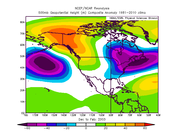
Above is what the winter of 2002-2003 looked like. This goes along with the ideas that we have with a trough to the south of Alaska, ridge in the Western US, and a trough in the Eastern US.
If you recall in the Northeast, during the month of December in 2002 there was monster Christmas Day blizzard, also record-breaking blizzards in February as well.
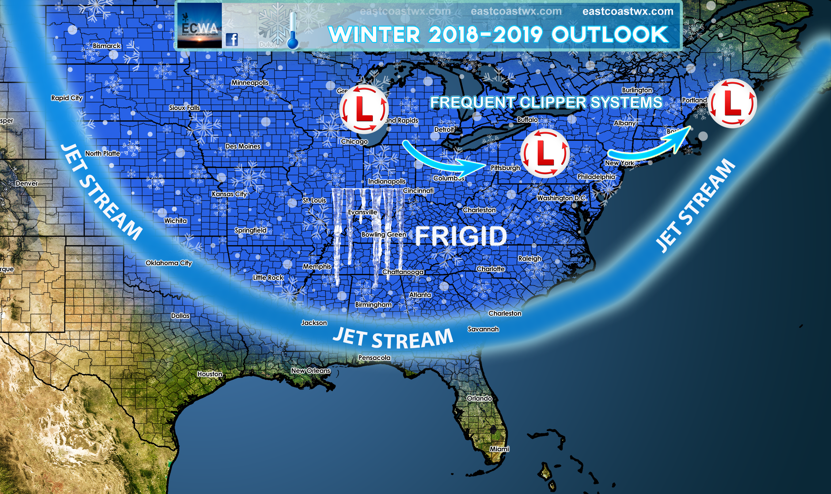
This winter looks to mimic 2002-2003 with cold outbreaks and major winter storms as we are very confident in this forecast due to all signs leading in that direction.
Carolina Weather Authority
Be sure to like us on Facebok! www.facebook.com/carolinawxauthority
You must be logged in to post a comment.