
At first, it was thought that the Southeast Ridge would dominate our pattern leading into the first week of December (which starts tomorrow). But things have shifted, and the Polar Vortex is expected to send chunks of cold air down our way repeatedly into the 10th, or even longer.

The first wave of activity is expected on Tuesday this week, as a storm system moves over the East Coast. Most likely this will be a cold rain for us, but a wintry mix is possible in the mountains or even locations near the NC/VA border.

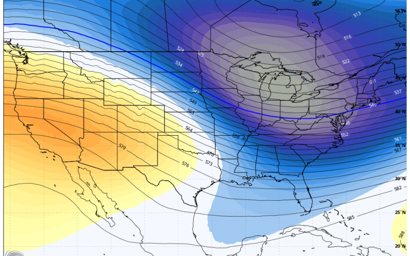
After Tuesday temperatures begin to modify into the remainder of the week, but then on Saturday a piece of the Polar Vortex parks itself over the Hudson Bay. This could mean yet another shot of cold air. The images are the Euro ensemble mean, so they are smoothed out compared to what could actually happen, which would be a deeper East Coast trough.

Even after then, into the 10th, we are looking at another outbreak of cold air and potential storm system for the East Coast. So the pattern is overall sustained cold into the first week of December, and into the 10th. There could be slight rebounds at times, but cold air intrusions will keep those to a minimum.
Total snow amounts are very light, and anything in the gray should be discarded. That is very light computer output and more than likely won’t happen. However, we won’t rule out the possibility of a few flurries escaping from the mountains into the Piedmont one or two times.

Keep the winter coat, hat and gloves handy as our average temperature is descending into December. Might be a good idea to stock up on firewood.
-Mike G.
Carolina Weather Authority