
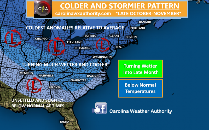
FLIP TO COLDER, STORMIER PATTERN STILL EXPECTED LATER THIS MONTH, BUT UNCERTAINTY LOOMS
As we stated this past weekend in our article, some periods of colder and stormier weather are possible for the second half of this month into November. We still expect this to occur. However, this doesn’t mean we will be consistently cold. There will still be a number of considerably warm days in the Carolinas, but the stagnant summer pattern is eradicated and is very unlikely to return. The overall consensus in our forecast is for a gradual step down to more autumn-like conditions, (which is normal), but also more unsettled weather, which should provide for more beneficial rainfall over time to alleviate the drought. In the more abnormal sense, some notable, early season cold shots are possible eventually as well. However, there’s a considerably amount of volatility in the overall pattern moving forward that could dictate just how much cold and wet weather we experience. Numerous players on the field globally will dictate the longer range pattern going forward, and with the atmosphere adjusting to seasonal changes, we can expect some uncertainty and inconsistency in the forecast modeling moving forward.
TAKING A LOOK AT THE MJO
We previously discussed the teleconnections last week, known as the NAO, AO, and PNA. The overall projection at that time was for a transition into the colder phases for later this month to favor colder and stormier conditions in the Eastern US for late October into November. Since then, we’ve seen a great deal of inconsistency in the forecast modeling in regards to these indices, but we remain consistent in the idea that we will still in fact still see the changes in the pattern alluded to a few days ago. Another item we like to look at is the Madden Julian Oscillation or (MJO). This is the current weather ongoing in the tropics that often has a huge role many times in how our global patterns and associated teleconnections react. There are a number of phases of the MJO that dictate the patterns downstream in the United States. Additionally, the greater the amplitude of that phase, the higher the likelihood of it having more of an influence in the overall global pattern, including North America. Here is the latest MJO forecast plot from NOAA:
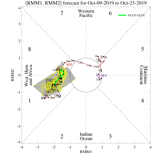

Currently, the MJO remains in phase 1. This is where cold air begins to pour into the northwestern part of the country, with milder weather seen across the south and east. You can see that reflected in the temperature composite graphic above, and that’s fairly close to where we’ve been, and where we currently stand. Even though we’ve cooled off notably, we still remain fairly close to normal, or even milder than normal in the Carolinas. Additionally, if you look at current temperature anomalies over the country, you’ll find that aside from some minor differences, the map below is at least moderately similar to phase 1 of the MJO:
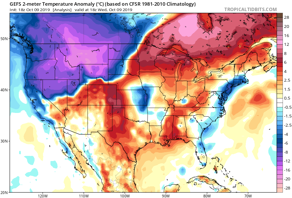
The cooling you see along the East Coast is courtesy of high pressure over the Northeast, funneling in some cooler air. As we head into the end of this week, we’ll be running slightly milder than average in correlation with that MJO phase. Additionally, this pattern is also not conducive to a lot of rainfall over the Carolinas. We have a front moving towards us later this upcoming weekend for instance, but cooling and rainfall will both likely be fairly limited. However, we should see this begin to change over time as the MJO propagates into other phases. If it can move into phase 2, we will see an increasing likelihood of colder and stormier conditions over the Eastern US. Some modeling for the MJO indicates that such should occur later this month. Additionally, various other teleconnections can sometimes diverge from the MJO phase, leading to a different result. However, oftentimes the MJO will dictate the overall swing of the pattern, and the role of various teleconnection phases, and lately we are seeing just that.
ANALOG SHADES OF AUTUMN 2014
More consistent methods we like to use in long-range forecasting are analogs. Analogs are tools where seasonal patterns and global temperatures of one year are used to forecast a similar current pattern or an upcoming one. Oftentimes analogs will dictate the overall state of the atmosphere and are more stable then teleconnections. Right now, there seems to be a close correlation with the autumn season of 2014. This has been accessed by a number of long-range forecasters lately, and carries considerable weight in validity for the potential pattern down the road. Take a look at our current October sea surface temperatures:
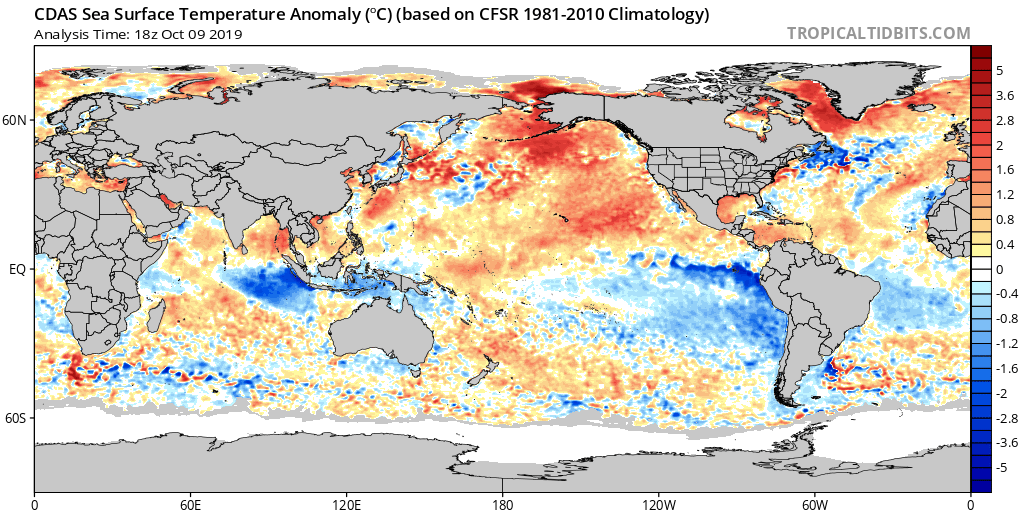
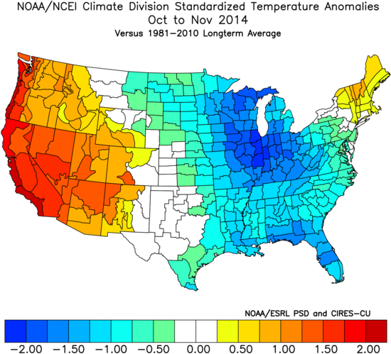
Now take a look at the sea surface temperatures observed in October 2014:
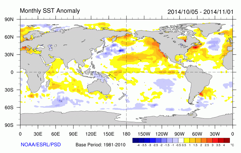
If you notice, there’s a considerably close similarity. Now obviously, there are some differences, and a number of different factors at work in the pattern , but a similar outcome to that year has the potential to play out in the weeks ahead going further into our autumn season. What we do know about October into November of 2014 is that much of October wasn’t overly cold, and even featured very mild temperatures at times. The month skewed a bit warmer than average overall by the time it was over, but a drastic change begin occurring in the pattern late October into November when deep troughs begin digging in, bringing rather unseasonably cold air masses into the country which made the period seem more like winter than autumn. As you can see, the standardized temperature anomalies from October into November that year skewed much colder than normal, despite milder weather earlier in October:
THE TYPHOON RULE
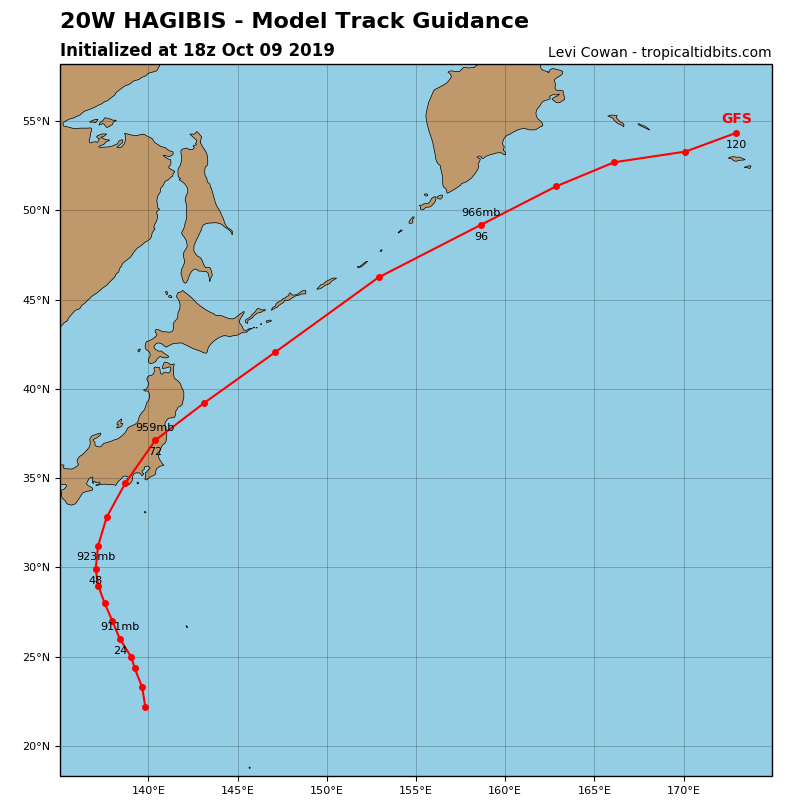
Another factor very influential in what happened in the autumn of 2014 could once again be present currently; re-curving typhoons. Typhoons that re-curve in the Western Pacific this time of year often lead to a buckling of the jet stream patterns in North America that can send troughs digging into the United States 6 to 10 days down the road. Right now we are watching Typhoon Hagibis that is expected to re-curve within the next few days, which should result in a trough over the United States sometime next week. The models clearly indicate a re-curving of Hagibis at the end of this week:
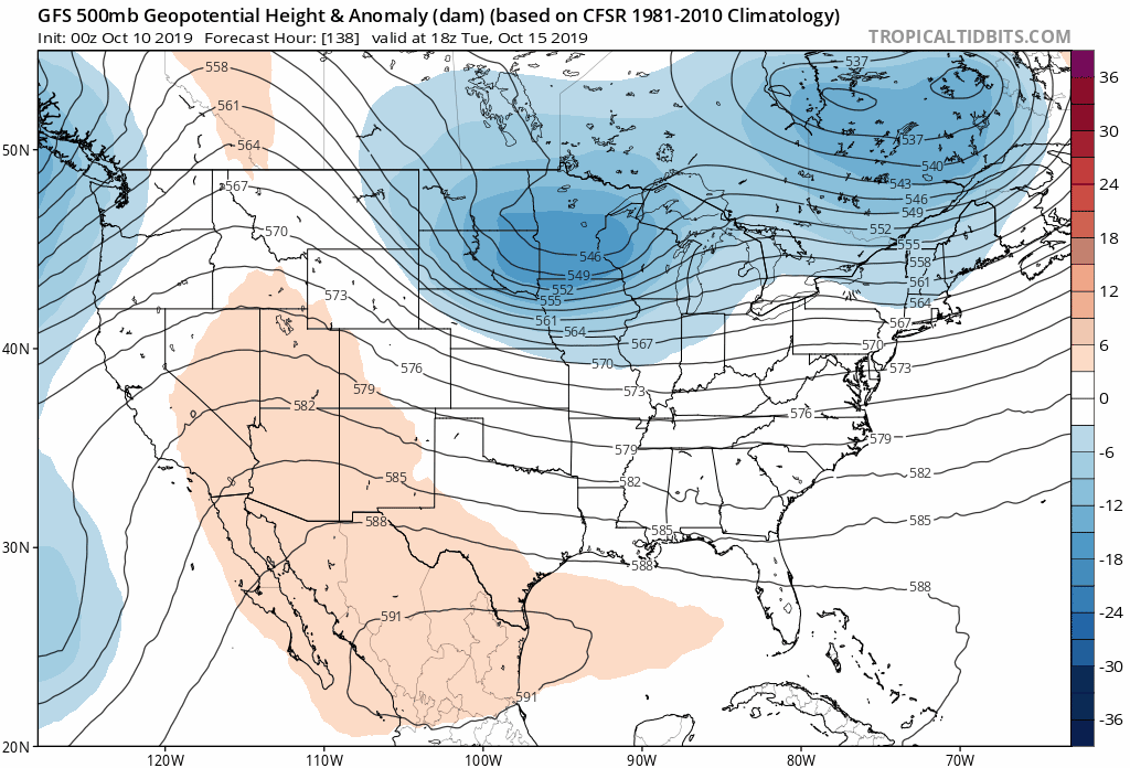
If we look at our forecast modeling, we indeed have a trough developing in the jet stream by the middle to latter part of next week and swinging into the Eastern US. The exact magnitude of this trough is still uncertain, but it may bring some meaningful rainfall, and a chilly shot of air in it’s wake by the mid to latter part of next week:
This may be the first in a series of deep troughs later this month that will correlate with our projections. If you notice, there’s already another one swinging in right behind it. However, the exact magnitude, placement, and timing of these future troughs will be determined by what we’ve just discussed. Can the various teleconnections and global pattern drivers line up to deliver a colder and stormier regime for the Carolinas and East Coast later this month into November? If we see the suspected analog of 2014 win out, we will likely see everything fall into place for the colder and stormier pattern we are expecting. If the MJO should continue to stall in phase 1, and the other teleconnections fail to transition to the colder phases, we may very well experience a milder outcome.
THE BOTTOM LINE AND OUR CURRENT FORECAST
With the exception of a few warmer days, expect a continued step-down to more seasonable autumn conditions going further into this month, but some shots of colder air are possible in the latter half of this month, increasing in likelihood by the end of this month into November if the various analogs and pattern drivers progress as expected. Conditions should also become more favorable for an increase in wet weather, and we can’t rule out the first snowfall in the mountains between late October into early November. There will also be the first potential for frost and freeze in the mountains before the month is over, with the first for the Piedmont possible by early November. Expect some mild conditions still possible at times, but an overall colder and wetter late October into November is currently expected. We will continue to keep up with the latest on model and teleconnection trends, and update you of any changes. Nothing is set in stone, and we will adjust our forecast accordingly in the weeks ahead. Stay tuned here on the site, and on our Facebook and Twitter pages for updates. We will keep you informed.
-Jesse
Carolina Weather Authority
You must be logged in to post a comment.