
POTENTIAL FOR RIP CURRENTS AND FLOODING ISSUES THIS WEEK FROM MULTIPLE DISTURBANCES
A trough located over Florida spawning currently some convection will move into the Western Atlantic Tuesday and may collide with a frontal boundary and developing low just off the Southeast Coast by Wednesday.
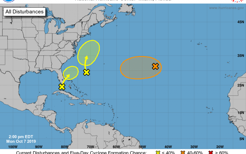
According to the National Hurricane Center, chance of tropical development is currently around a mere 10%, and the system should remain considerably offshore of the Carolinas. Regardless of that, some notable impacts are possible to the Eastern Carolina coastal areas, particularly in North Carolina. The risk of rip currents will be highest there, and the probability of coastal flooding will also be elevated. The highest risk of rip currents and coastal flooding will come Thursday into Friday as the system tracks northeastward. An additional flood threat may come prior to that in some areas of extreme Eastern North Carolina, which could see multiple inches of rainfall Tuesday into Wednesday from the developing low pressure off the coast, ahead of the other wave, so stay tuned if you live in that area.
The main focus area is centered in Coastal North Carolina, with the main threats being the slight potential for flooding rainfall Tuesday into Wednesday, and a rip current and coastal flooding risk Thursday into Friday. Stay tuned to Carolina Weather Authority for the latest on this tropical system here on the side and on the Facebook and Twitter pages.
-Jesse
Carolina Weather Authority