
TRANSITIONING FROM A SUMMER-LIKE PATTERN TO A MORE AUTUMN-LIKE ONE AND BEYOND
After remaining in a fairly stagnant pattern for several weeks, we’re finally beginning to cool off. A backdoor cold front has already provided a decent taste of autumn-like conditions this afternoon and will keep temperatures comfortable the rest of this weekend. This is the first of many changes in a stubborn pattern that we just haven’t been able to shake. Meanwhile, changes have been ongoing behind the scenes that will eventually begin to shape our weather down the road. Let’s take a look at our recent pattern:
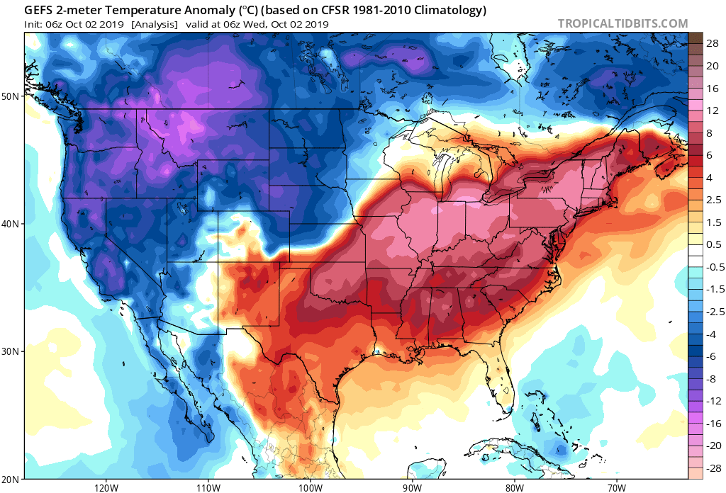
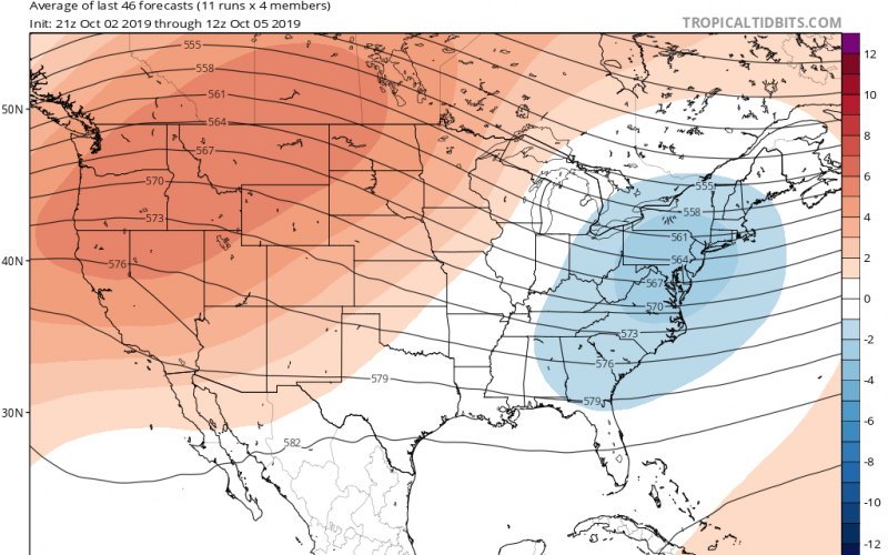
If you notice, the coldest anomalies relative to average have been centered in the north and west where there’s been a trough in the jet stream, with the warmest anomalies over areas east of the Rockies, and especially east of the Mississippi River, where a stubborn ridge of high pressure has been locked in place for the majority of September into this first week of October. This is why we have been so hot and dry, while the north and west has been cold, stormy, and even snowy in some states recently. When a ridge like the one recently parked over the east is locked in place, heat becomes more excessive as southwesterly flow drags warmer air up from the south, which explains the record-breaking pattern that we’ve recently endured. Additionally, significant weather systems are not able to penetrate through the high pressure. Thus, rainfall becomes lackluster, with any rain events being mainly from meager localized convection during the heat of the day, if any at all. Drought has become a real issue for the Carolinas because of this stagnant pattern. Very gradual change in this issue is expected, but we should be looking at more substantial relief within the next several weeks as the upcoming pattern promises to deliver a considerably wetter outcome.
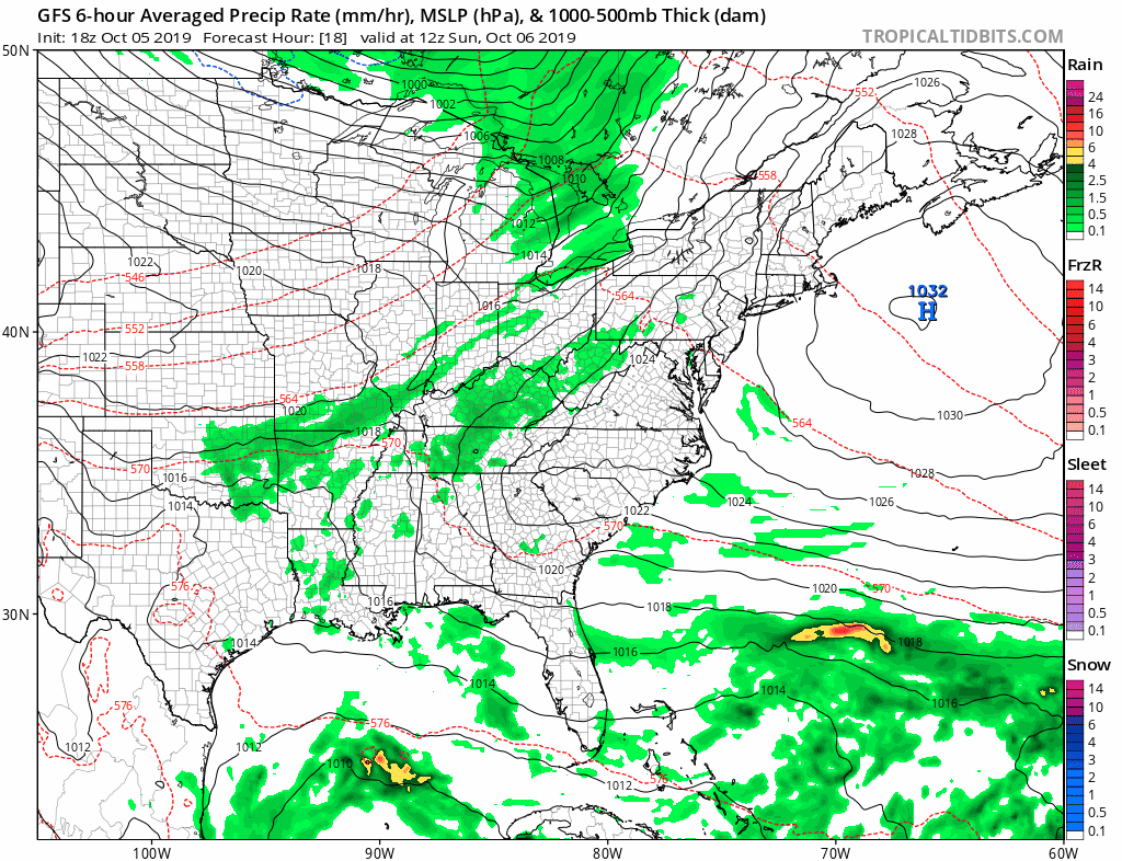
Looking ahead to next week, we have a cold front on the way, moving from the west that will bring us more rain showers late Sunday through Tuesday night, and even cooler temperatures to the entire area thereafter. Recent modeling trends have actually shown the cold front merging with a coastal low. This should enhance rainfall across the eastern half of the area, while some light to moderate showers will be possible in the rest of the Carolinas. Check out the latest run of the GFS model:
Behind it, temperatures cool significantly, and we enter a very autumn-like pattern. Highs next week after Tuesday will likely be mainly in the 70s, with lows in the 50s. This will definitely be a great week to get out and about if you have outdoor plans.
LONG RANGE MODELING AND TELLECONNECTIONS SIGNAL POTENTIALLY COLDER AND STORMIER SECOND HALF OF OCTOBER INTO NOVEMBER:
Now that the ridge is breaking down, we’re starting to see a notable switch-up in our overall pattern. Not only are we no longer seeing a strong ridge in place, but we’re starting to see the jet stream become more volatile, and colder air come into the US. This is a trend that is likely to become more noticeable and more widespread in the upcoming weeks.
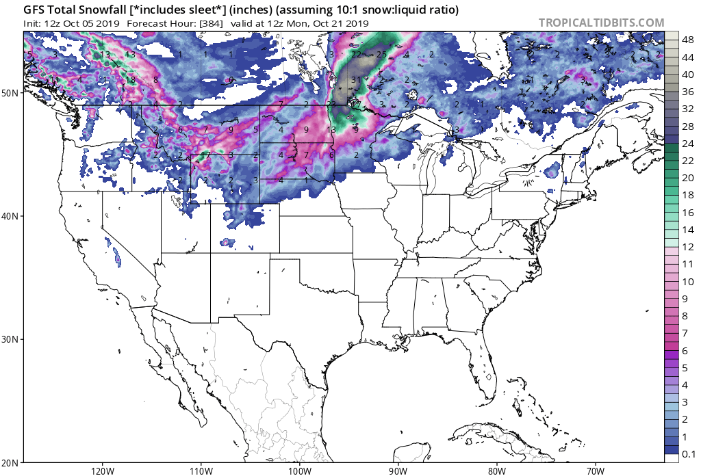
As posted previously, we’ve seen an increase in snowfall over the Northwest, and it’s possible that this trend continues to include more northern sections of the country later next week. Behind the first trough early next week, yet another is possible out in the Central US by next weekend. This could bring snowfall to parts of the Plains next week. When you start to lay down substantial snowpack across the north this early in the season, this can oftentimes lead to colder weather in the East over time. When colder air masses begin diving in from the north, they modify less over areas that have snow pack, and carry more of a punch if they can make it to the East. While not exact, and likely exaggerated in some areas at that range, the 384 hour snowfall output from the GFS shows healthy snow cover beginning to build over the north:
We’re starting to see more volatility in the overall pattern with these troughs digging into the north and west, and in the modeling we’re seeing the cold air masses associated with them become more significant. What’s more important about this upcoming pattern is that we’re going to start to see these troughs swinging more into the East over time. The reason being is that our teleconnections are soon to enter a more favorable state for a cooler pattern east of the Rockies.
The first of several teleconnections we keep an eye on is the North Atlantic Oscillation, or the NAO. The NAO has a positive phase and a negative phase. When it’s in the positive phase, it results in more troughing over the northern latitudes, such as Greenland, which in turn allows milder air to infiltrate the Eastern US and the flow to become very zonal, with storm systems usually failing to amplify, and often remaining fairly weak in their passage through the Eastern US. When the NAO in it’s negative phase, higher pressure builds in the northern latitudes, and results in cooler, stormier weather over the Eastern US. If we take a look at the 14 day forecast for the state of the NAO, we notice it turning negative later this month:

This could correlate to much cooler and stormier conditions in the Carolinas later this month.
Another teleconnection we often look at is the Arctic Oscillation, or the AO. This teleconnection has to do with the state of the well known “polar vortex” that has been so commonly referred to since 2014. During the positive phase of the AO, the upper level winds in the polar vortex over the Arctic are stronger. This keeps the cold air from the Arctic locked in place, and void of any distribution southward to affect the US or Canada. When the AO is in the negative phase, the upper level winds of the polar vortex weaken, allowing the colder air to spill southward into Canada and the US from the Arctic. If we take a look at the 14 day forecast for the AO, we find it is projected to turn negative later this month:
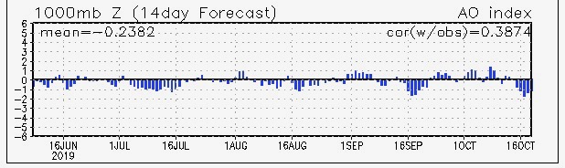
This could also correlate to much cooler and stormier conditions in the Carolinas later this month.
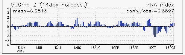
One last teleconnection of importance coming up, is the Pacific North American teleconnection pattern, or PNA. This one is reversed in phase results in comparison to the other two teleconnections. When the PNA is in its positive phase, we see a ridge in the jet stream along the West Coast. This allows troughs in the jet stream to swing east of the Rockies, which allows colder air from the north to move south and affect the Eastern US. When it’s in it’s negative phase, we see a trough form in the jet stream over the West, which promotes cold and stormy conditions there, while a ridge forms over the East, creating warmer than normal conditions. The record stretch of heat we just experienced was a direct result of the negative PNA. As we go later into October, modeling tells us that this is indeed also going to flip, sending us into a setup that favors more troughs in place of our previous ridging. The 14 day forecast for the PNA shows it indeed wanting to eventually go positive later this month:
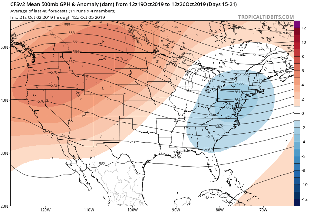
So what can we expect? Going later into this month, we here at Carolina Weather Authority expect a much cooler, and eventually wetter pattern than what we’ve seen the last several weeks. As previously mentioned, we do have a substantial drought, but that should start to erode over time as the pattern turns more unsettled. Multiple systems should start to bring beneficial rainfall to the Southeast and that pattern is also expected to increase going into November. As far as temperatures are concerned, many of these troughs moving into the East should bring some very cool bouts of autumn-like weather. However, some of them could deepen more to bring some downright unseasonably cold air masses into the East; even the South. If we look at the CFS model forecast for week 3, we can start to see more notable troughing developing over the Eastern US and this correlates with the various colder teleconnection phases:
Be on the lookout for the first frost and freeze potential for the mountains later this month, and possibly parts of the Piedmont between the end of October and first half of November. We’re also watching for the possibility of the first snow of the season for the higher elevations before the month is over with some of these troughs really digging in. This is not uncommon for the Appalachians in late October, but it should be at a higher likelihood of occurring this year. Another item to watch is tropical activity. Remember, October is still a part of the tropical season. We could still have something flare up before the month is out. Furthermore, sometimes tropical systems can merge with digging troughs over the Eastern US to bring about rather hybrid weather setups. While not a high likelihood, we cannot rule out something like that occurring this year with the way the pattern appears to be unfolding.
With all that being said, this doesn’t mean that there won’t be any more warmth in the Carolinas this month. There will be several warm days. However, what you’ll likely find over time is not only a seasonal cooling trend, but some episodes of unseasonably cold weather possible down the road. The risk for early-season cold shots is increased for the latter half of this month, and anymore extended stretches of above normal temperatures are fairly unlikely. We will likely skew cooler than average from late October into at least part of November.
Make sure to stay tuned to Carolina Weather Authority for the very latest developments as we head deeper into the autumn and closer to the winter season. We’ll likely have information regarding the upcoming winter in the weeks to come, so stay tuned for that.
-Jesse
Carolina Weather Authority
You must be logged in to post a comment.