
Unexpected Burst of Sunshine for Central NC
I was pleasantly surprised here in Raleigh to see the sun come out in earnest around 7:00pm. While most of the models yesterday suggested more rain and clouds, those models definitely missed the mark for the second half of the day. The primary reasons for the sudden burst of sunshine across Central NC was a combination of dry air being drawn into the cut off low as well as a faster-than-expected northward movement of the low itself.
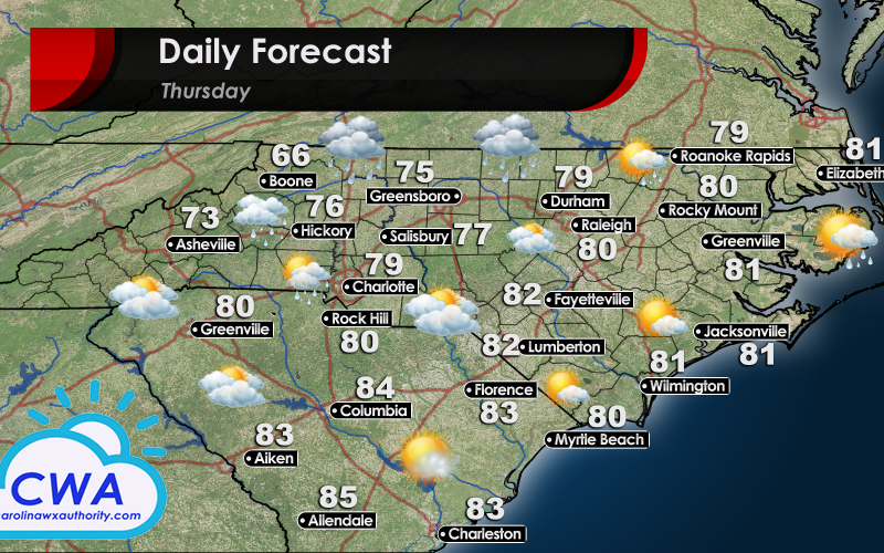
Pleasant Weather on Tap for Thursday
Even with the positive developments this afternoon, Thursday’s forecast continues to be complicated. The cut off low will eventually weaken late Thursday or early Friday. However we are not done with it’s influence yet. While the models continue to be rather insistent on rain chances for midday Thursday, I am not buying it. We certainly can not rule out a stray shower here and there for Central and Western NC. However, I think the precipitation will be light and short lived.
The only areas where I think there could be more consistent rain (and even possibly a stray thunderstorm or two) is for the areas along the NC/VA border. Especially for areas along a line from Greensboro/Winston-Salem to Boone, and points north along the VA border, I think these locations will have the greatest chance for widespread rain showers. The Triangle, Charlotte, and especially the Sand Hills region should all be more or less dry, and even partly sunny!
For South Carolina, the chances of rain are very low. The sunshine should be widespread and furthermore, with relatively low dew points, it should feel like a crisp spring day! Temperatures will be higher than on Wednesday. The winds will be predominately out of the south, but the cooler air mass that is already in place should hold (although weaken) through the day. This wind pattern will stick around through the weekend, eventually breaking down the cooler air and generating warmer and muggy conditions, so enjoy this spring-like day!
You must be logged in to post a comment.