
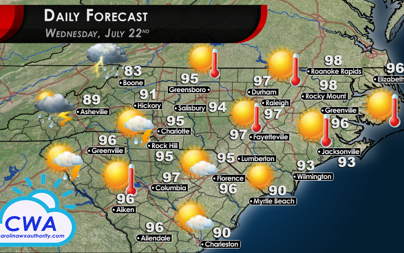
Daily Forecast for Wednesday: More Extreme Heat
I’ll be honest with you, I really wish I had something, anything, else to report. However, let’s try to break up the endless heat-forecasting with

an awesome photo submitted by a follower of CWA from Facebook! Here, you can see the skyline of Charlotte being completely overshadowed by an ominous looking Towering Cumulus cloud!
These clouds form like any other: moist air rises and cools as it enters the middle layers of the atmosphere. As the air mass cools, the water begins to condense from a gas to a liquid.
These Towering Cumulus clouds form when the air mass is rising very rapidly and is laden with a great deal of moisture. Condensation of water vapor is an exothermic process, meaning it warms the environment around it. When enough condensation is occuring, the extra heat that is generated can super-charge the lifting process. This means the air mass, which is rapidly cooling down due to the cold temperatures at altitude, can continue to rise as it maintains its heat.
Big thanks to Demetrius A. Byrd for allowing us to share this great picture! If you have any videos or photos of weather happening in your neck of the woods, please feel free to share them to us! You can message us on our Facebook Page, or email us at [email protected]!
Now, let’s get back to the terrible news at hand.
Daily Forecast: Little to No Changes for Wednesday’s Forecast
The Daily Forecast for Wednesday is, once again, brutal. A persistent high pressure system continues to sit near the region. This system is causing hot stagnant air to dominate the region. You may have noticed any thunderstorms that pop up are barely moving, and this is partly the reason why.
Expect high temps in the upper-90s for most locations. Thunderstorm chances continue to be weak, at best. There is energy moving in, from the west, but the mountains have so far prevented any significant action from occurring. The best chances to see rain/thunder showers will be in the Charlotte, Rock Hill, and Greenville SC areas. The rest of us are going to have to just keep on keeping on.
Stay safe, stay hydrated, and enjoy your hump day!
-CWA
You must be logged in to post a comment.