

Good afternoon ECWA followers!
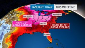
An upper level ridge and high pressure at the surface is keeping things warm for a majority of us on the east coast. It’s certainly warmer than average, but how do we stand versus normal and record temperatures? Many have been asking if this is the warmest air mass we have ever seen for this time of year on the east coast. Let’s take a look at three eastern cities for the next few days to see if that is the case.
*Data taken from local NWS offices*
Boston, MA Normal Temperature Record Temperature Forecasted Temperature (2018)
January 20th 33 60 – 1951 47
January 21st 33 68 – 1906 49
January 22nd 33 66 – 1916 40
Temperatures are forecasted to be nearly +15 degrees from normal temperatures for this time of year. However, Boston is no where near record temperatures for these dates.
Charlotte, NC
January 20th 51 71 – 1951 62
January 21st 51 73 – 1935 64
January 22nd 51 74 – 1937 61
Temperatures are forecasted to be +10-15 degrees from normal temperatures for this time of year. However, Charlotte is nearly 10 degrees cooler from record temperatures observed historically.
Roanoke, VA
January 20th 46 69 – 1951 61
January 21st 46 74 – 1932 60
January 22nd 46 74 – 1932 58
Temperatures are forecasted to be +10-15 degrees from normal temperatures for this time of year. However, Roanoke is nearly 15 degrees cooler from record temperatures observed historically.
Summary : While we are certainly enjoying above average temperatures for this time of the year, record highs and heat are no where near record temperatures observed in the past on these days. It has been hotter before on these days. This is not an extraordinary event, but it certainly is an enjoyable one!
—Matt
You must be logged in to post a comment.