
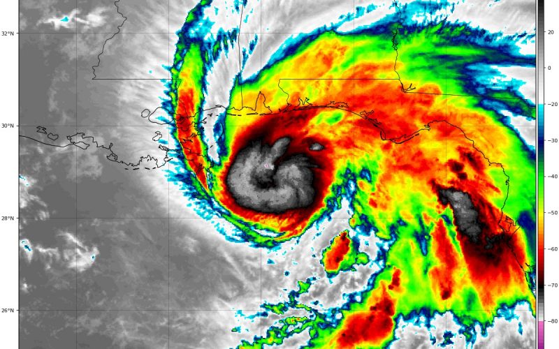
Hurricane Sally is still over the open Gulf waters tonight, and she is still strengthening as a result. According to the latest forecast from the National Hurricane Center, she is set to slam either the Alabama or Mississippi by 7 am Wednesday. Since she is slow-moving, she will have more time to strengthen, and possibly become a Category 3 hurricane. It is not known whether or not she will be a Cat 3 at landfall, as the NHC has her weakening slightly just before landfall.
According to the official forecast:
FORECAST POSITIONS AND MAX WINDS

INIT  15/0300Z 28.9N  87.6W   85 KT 100 MPH
 12H  15/1200Z 29.1N  88.1W   95 KT 110 MPH
 24H  16/0000Z 29.6N  88.4W   90 KT 105 MPH
 36H  16/1200Z 30.4N  88.3W   85 KT 100 MPH...INLAND
 48H  17/0000Z 31.3N  87.4W   50 KT  60 MPH...INLAND
 60H  17/1200Z 32.0N  86.3W   30 KT  35 MPH...INLAND
 72H  18/0000Z 32.7N  84.9W   25 KT  30 MPH...INLAND
 96H  19/0000Z 33.1N  82.3W   25 KT  30 MPH...POST-TROP/REMNT LOW
120H  20/0000Z...DISSIPATED
It only takes 111 mph to make a major Category 3 hurricane, and the NHC above has the wind speeds at 110 mph which is a maximum Category 2 hurricane. However, before landfall the official forecast calls for it to remain a Category 2 storm.
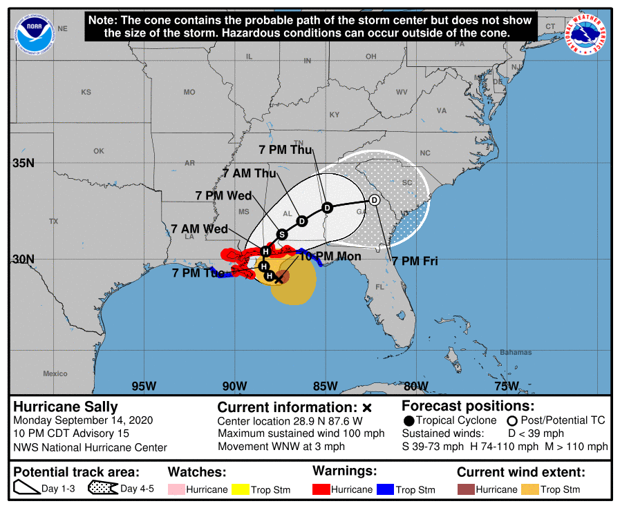
Residents along the Alabama and Mississippi coastline need to prepare for a Category 2 or 3 hurricane, since rapid intensification is not off the table. There is the potential that this storm could be slightly stronger at landfall. A major hurricane making landfall would cause widespread devastation, as well as inland flooding.
Very heavy rains are expected as this storm moves inland and makes a turn to the east. Afterward, Sally will weaken to a depression and will transition into an extratropical low.
Later this week the remnants are expected to cause heavy rain for the Carolinas before being swept out to sea by a strong cold front. After the front moves through, the Carolinas can expect to see a very nice fall-like weekend with nighttime lows in the 50s along with a wood fire smell in the air.
Stay safe, and stay with us!
~CWA
You must be logged in to post a comment.