
Tropical Storm Isaias has shown some signs of coming back to life this afternoon as the center of circulation remains off the East Coast of Florida over warm Gulf Stream waters. While wind shear has created conditions that are unfavorable for any strengthening, the core of the storm has been able to fend off shear for several days now, and winds of over 60 mph have blasted Grand Bahama Island earlier today, causing widespread storm surge flooding and damage to an island still reeling from last September’s Hurricane Dorian. Forecasts from some sources of a landfall first on the Florida coast look to have not unfolded as most of the rough weather has remained just offshore.
Forecast guidance has performed poorly thus far with the environmental conditions surrounding Isaias, but the storm remains healthy enough to cause a lot of rain and enough wind and surge to provide damage to coastal communities. While today’s track has slowed considerably with high pressure northeast of the storm creating some blocking in his forward speed, an approaching trough of low pressure west of the Appalachians will begin to guide Isaias northward and away from Florida’s First Coast overnight tonight, and then the storm will accelerate north-northeastward right towards coastal South Carolina late tomorrow afternoon into tomorrow evening. The storm could be a hurricane at that point, though most of the forecast guidance indicates that he will be a strong tropical storm up until landfall later tomorrow night between McClellanville, SC, and Bald Head Island/Cape Fear, NC.
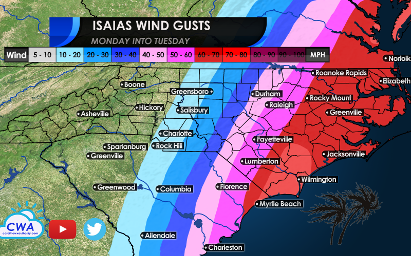
The worst of the wind remains well northeast and east of the center, but could consolidate closer to the storm’s track Monday night as he moves close to landfall. Thus, wind gusts over 60 mph to perhaps as high as 85 mph could blast coastal locations near and just right of where Isaias comes onshore Monday night, particularly across coastal Brunswick and New Hanover Counties. Any shift left of the forecast track could increase the threat to Horry County, South Carolina.
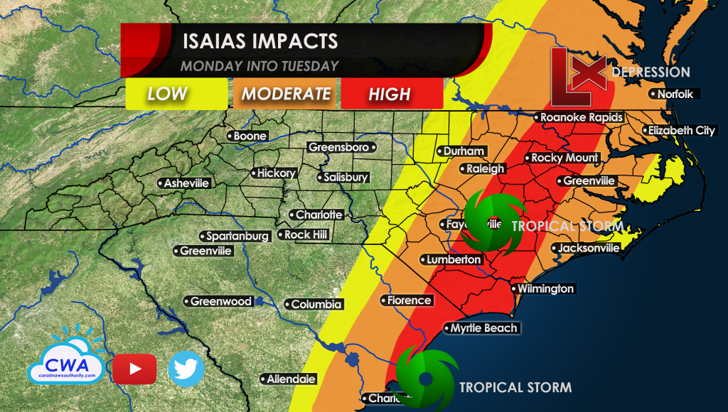
Right now a tropical storm watch is in effect, but don’t be completely surprised to see an upgrade to a hurricane watch and then warning if Isaias is able to restrengthen. Then, winds of tropical storm force will quickly advance inland and along the I-95 corridor Tuesday morning, with power outages possible in locations like Wilmington, Goldsboro, Greenville, Wilson, Rocky Mount, Roanoke Rapids, and Jamestown. Areas east of the track could also have a risk for a few quick-lived tornadoes. Areas just west could have flash flooding, including Charleston, Florence, Lumberton, Fayetteville, Raleigh, and Richmond.
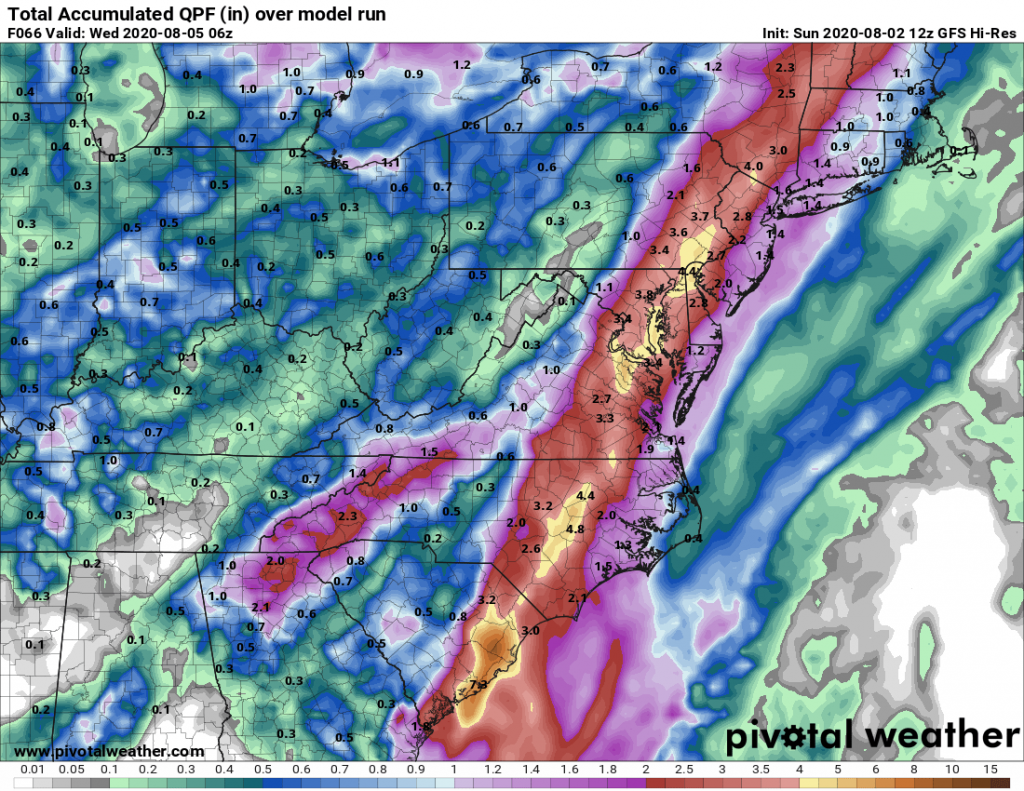
Models are in general agreement that the storm will weaken slowly but not as fast as you would expect with a landfalling storm, as winds aloft carried by the jet stream approaching from the west could keep Isaias as a tropical storm as far north as New Hampshire and Maine on Wednesday. Thus, flooding is expected in areas like Baltimore, York, Lancaster, Reading, and up into eastern New York, northwest New Jersey, and western New England. Millions of lives could be impacted by Isaias in just a few days.
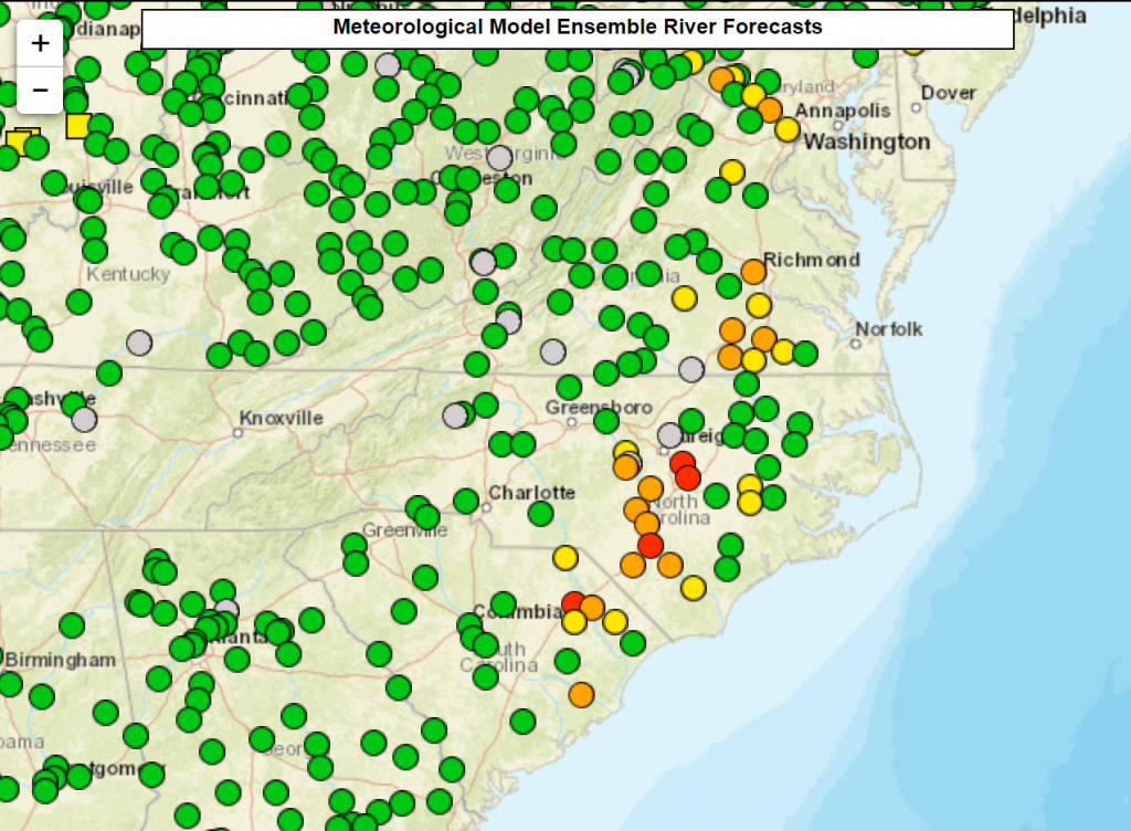
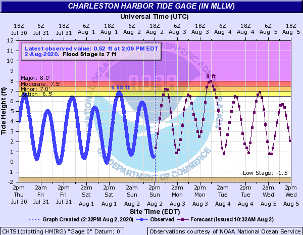
Currently most area rivers are still on the high side from all the rain we’ve had dating back to May. While a repeat of flooding seen in Matthew and Florence is definitely not anticipated, some area rivers like the Cape Fear, Neuse, Lumber, and Pee Dee Rivers could reach flood stage over the coming days, putting homes impacted by earlier floods once again in a tough spot. Be prepared to have a plan in place should you be in a flood zone. In addition, a new moon on Monday could aid in flooding at high tide in Charleston, as the harbor is expected to crest at 8 feet on Monday evening as Isaias approaches from the south and passes by just east of the area.
We want to stress that while forecasts today are in general agreement, the shape of the coast and timing and intensity changes could lead to major changes to what happens with the weather in your neighborhood. We will update you as these changes are needed. We expect several more minor adjustments that could have major consequences. No two storms are alike, and this one still has some waves to make in the forecast. We have found it is better to be overprepared than to be caught off guard.
Keep following us on our Facebook page for the latest, and check out our latest videos on our YouTube channel at: https://youtube.com/c/carolinaweatherauthority
You must be logged in to post a comment.