
Mild December Continues:
December thus far has been relatively mild if you haven’t noticed, with a few seasonably cool days/nights , but nothing spectacular and there hasn’t been any mentionable wintry precipitation!
Why is that? Well the Pacific jet stream has been flooding North America with mild air and occasionally you can get a dip in the northern jet stream that cools us back down, but it’s nothing meaningful because the Pacific jet is so strong, than any trough of cold air that tries to move through is transient, and on occasion this jet stream pattern allows the southeast ridge to pump north and we get warm as a Pacific North American pattern (PNA) begins to solidify. This pattern can be heavily correlated with what is happening with the Madden Julian Oscillation.
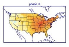
The Madden-Julian Oscillation (MJO) is a fluctuation in tropical weather patterns over the Indian Ocean near the equator from week to week. The areas of convective activity and inactivity over the Indian Ocean can determine the implications on the jet stream and heavily influence patterns in North America. Check out the pattern bias that phase 6 tends of this oscillation tends to result in:
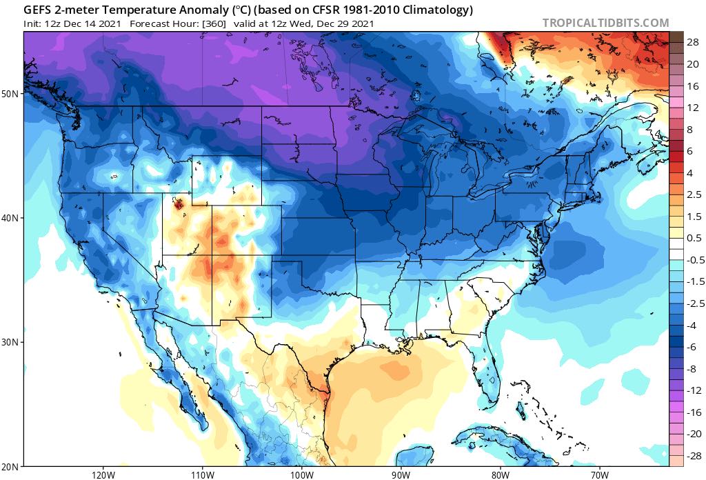
Now take a look at what the GEFS ensemble 5 day 2-meter temperature anomaly shows this week…
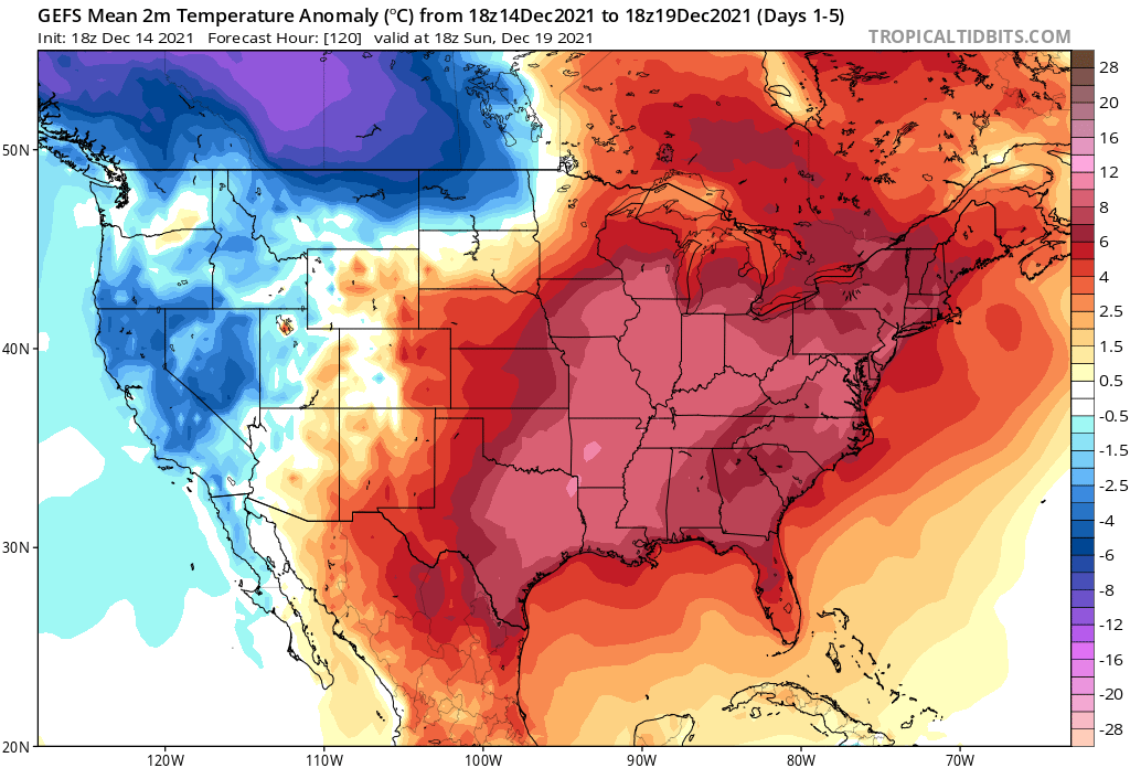
Notice the jarring similarities to that previous image in the ensemble image to excessively milder temperatures over the Central and Eastern United States from eastern ridging? This pattern will result in a lot of days in the 60s and 70s over the Carolina’s this week and a lot of seasonably cold nights and mornings in the 30s and 40s.
Christmas Week Changeable Pattern:
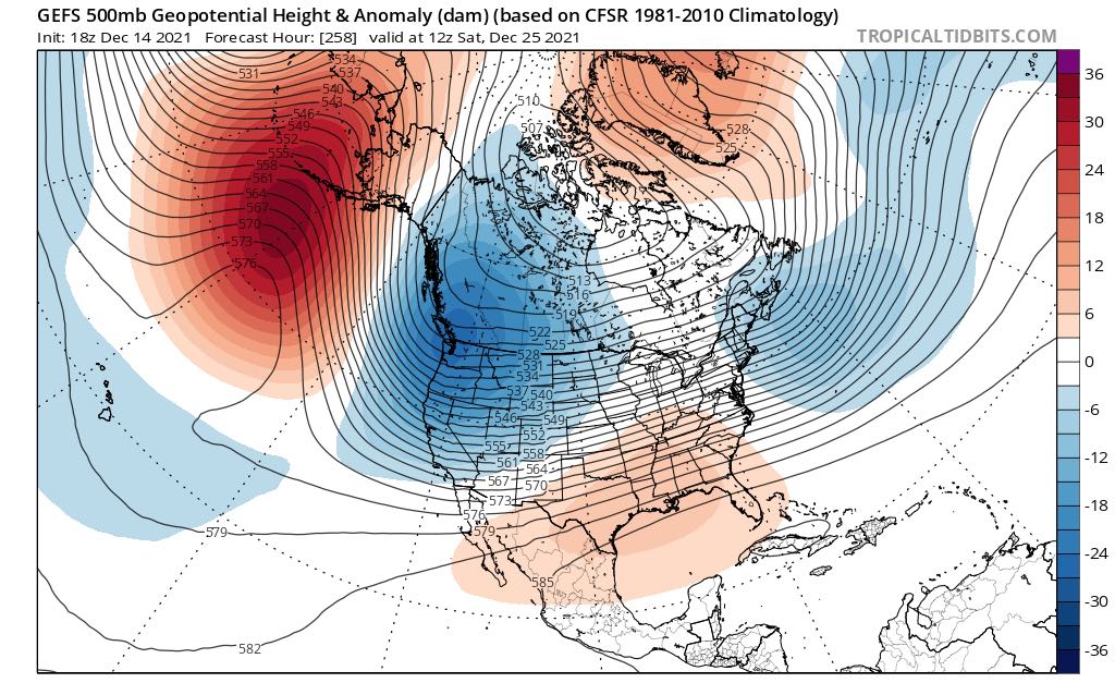
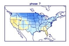
Going into this weekend/Christmas week it gets interesting because the trough of cold tries to press a little more, but is still centered over the west and you still have that southeast ridge in the way due to a negative PNA. This slight attempt at a shift in transient cold may be in part due to the MJO trying to propagate into phase 7, but lagging some from phase 6. This is where a fight sets up between the trough of cold and the ridge and you start to see a lot of precipitation. Check out the GEFS ensemble pattern for next week leading up to Christmas:
That being said, you can expect a lot of rain this next weekend over parts of the Southeast, at least in western areas.. Now perhaps we can bring a transient shot of cold air in prior to Christmas, and potentially see some wintry weather in the higher elevations, but I’m not seeing any signal for widespread wintry weather in the Carolina’s leading up to Christmas. As previously mentioned, the MJO is trying to move from 6 to 7, but it’s moving slowly. That may determine cooler risks versus warmer risks for the US, including the Carolina’s leading up to Christmas, and there is a chance that Christmas Eve/Day is milder, but that is far from set in stone during this changeable pattern.
New Years/January:
Beyond Christmas…going into the last days of December into the New Year is where the pattern gets somewhat more established and cold and stormy weather sets up a lot better, and then we can maybe start talking our first winter weather opportunities in higher elevations and/or northern areas. Check out the latest projected pattern from the GEFS ensemble for late December just after Christmas:
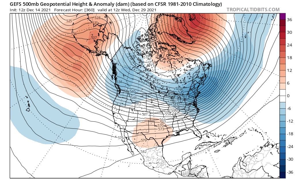
The GEFS ensemble projects a lot of blocking going up over the top and a ridge forming near Alaska that will set up some more cross polar flow that allows cold air to press more into the US. However, there’s still semblance of a -PNA pattern with a west coast trough showing in the guidance which means the southeast ridge may still be allowed to flex.
If that ridge flattens out more, and you get more cold, you can start possibly start talking some frozen precipitation across higher elevations or northern areas because the trough/ridge clash is still there creating overrunning precipitation, but if the ridge is too strong than it is more likely heavy rain.
This period is where the MJO has likely propagated into phase 7 and the results are more evident. It is a colder pattern, but it’s not perfect, but it may be enough to trend towards less of that western trough and less of a southeast ridge if there is enough amplitude in the MJO. The models still want to keep the trough on the west coast and that in turn keeps the southeast ridge still slightly present.
If it’s weak, then perhaps we can entertain the idea of some snow or ice over the higher elevations and areas north of Interstate 40. If the southeast ridge is a little stronger however, it might be more of a cold air damming situation and some opportunities for ice. If it’s considerably strong than that, than it’s heavy rain and maybe flooding. This is when the phase 7 MJO should start to have more of an influence on the pattern. That being said, perhaps the GEFS isn’t too far off on its latest projection in correlation to the MJO phase 7 for the end of December:
December MJO phase 7 temperature bias:
The GEFS for the 28th-29th:
That’s pretty similar to what phase 7 tends to result in over the Eastern US. Regardless of the exact temperature pattern, it’s an active and changeable pattern coming up, no two ways about it.
Furthermore, if the MJO can propagate into the phase 8, which has some support, that tends to be a pattern much more conducive to cold and even wintry precipitation into the Southeast as high latitude blocking sets up and the southeast ridge deteriorates. Here’s what the phase 8 biased temperature pattern tends to look like:
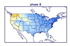
Snow lovers can only hope this occurs! January may be one of our more cold and active months this winter based off all of that and what I’m looking at now. I’m pretty confident we see a few opportunities for winter weather in at least parts of the Carolina’s in January. Stay tuned.
– StormTrackerSacher
You must be logged in to post a comment.