
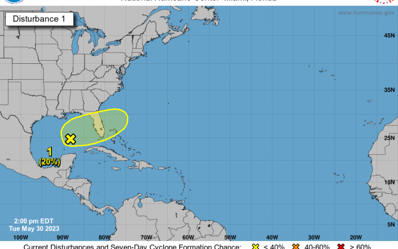
As we hope to dodge yet another wet weekend in the Southeast, another area of low pressure could be taking shape. I don’t know about you, but I’d like some sunshine and swimming weather. Sure, I like cool and cold too, but not since April. Lol. Anyway we are looking at a 20% chance of something forming in the Gulf later this week and into the weekend.
The official discussion is seen below:
Tropical Weather Outlook
NWS National Hurricane Center Miami FL
200 PM EDT Tue May 30 2023

For the North Atlantic...Caribbean Sea and the Gulf of Mexico:

1. Central Gulf of Mexico:
An area of disorganized showers and thunderstorms is associated with
a surface trough of low pressure interacting with an upper-level
trough over the central Gulf of Mexico. Environmental conditions
appear only marginally favorable for additional development over the
next several days as the system meanders over the eastern Gulf of
Mexico. The system is then forecast to move across the Florida
Peninsula this weekend and emerge into the southwestern Atlantic
Ocean by early next week. Regardless of development, the system
could produce heavy rainfall and gusty winds over portions of the
Florida Peninsula later this week. Additional information on the
rainfall and flooding potential can be found in products issued by
your local National Weather Service forecast office and Excessive
Rainfall Outlooks issued by the Weather Prediction Center.
* Formation chance through 48 hours...low...10 percent.
* Formation chance through 7 days...low...20 percent.

Forecaster Papin/Blake
Most likely, this disturbance will head out to sea. Some coastal locations could get brushed with some outer rain bands, however latest model guidance does not show it being a big deal, and if something forms it will move away from the coast.
Let’s hope for a sunny Saturday!
You must be logged in to post a comment.