
While efforts to keep the beautiful weather we had over the Labor Day holiday weekend came screeching to a halt earlier this week, the good news is that some more relief is on the way towards the middle of next week. Tropical rains and high humidity will remain in place through the rest of this week, with dewpoints remaining well into the 70s as moisture surges onshore.
In fact, much of the nation is seeing extremes right now, as extreme heat fuels incredibly powerful wildfires in the Western U.S., while an extremely early winter storm has coated parts of the Rockies with 6-12 inches of fresh snow – including some locations in Wyoming and Colorado that saw highs in the upper 90s to near 100 before temperatures tumbled nearly 75 degrees in less than two days! Salt Lake City saw strong wind gusts to hurricane force as that storm pushed south through the Rockies. And after a few nice days, the East Coast is experiencing extremely humid weather, with localized flooding plaguing parts of South Carolina and southeastern Virginia earlier today. Radar shows amounts of 8-10 inches may have fallen in a 6 hour period in places like Myrtle Beach and Pawleys Island, S.C.
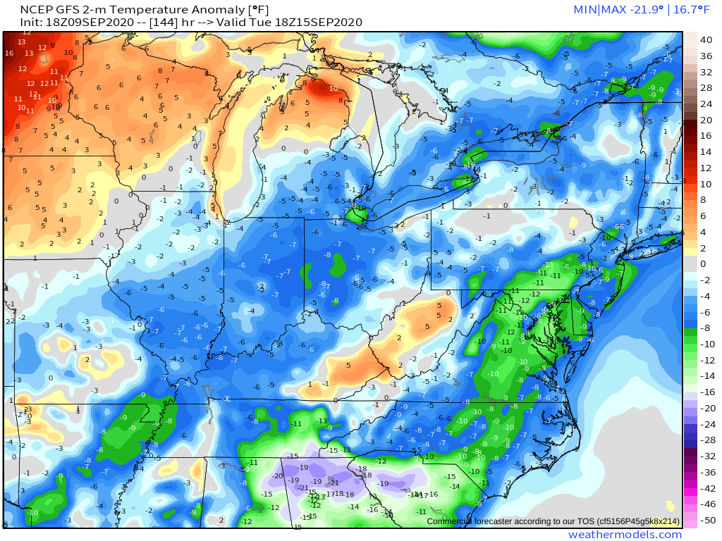
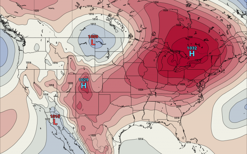
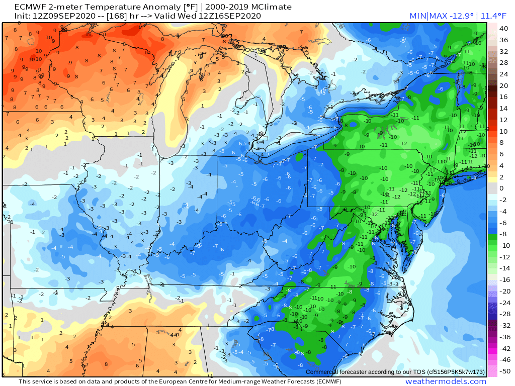
While tropical moisture will hang around through the end of the week and possibly into the weekend, a push of much cooler, comfortable air will spread east of the Mississippi later this weekend and then settle south into the mid-Atlantic and Carolinas Tuesday into Wednesday of next week. This cool spell won’t last more than a few days, but it will be a nice change to open up the windows as dewpoints are likely to dip into the 40s and low 50s in the mountains and 50s to low 60s in the coastal plain. That is also very much good news for leaf peepers hoping to see some nice fall color in the New England mountains in September and in the central Appalachians in early October after what’s been a hot summer across the region.
And while we are starting to see these progressively cooler air masses push southeast into the region now that it is September, it is certainly not time to write off the second half of the Atlantic hurricane season. We currently have Tropical Storms Paulette and Rene in the open Atlantic, and neither looks to be a threat to the U.S. at this time. But another vigorous wave coming off of Africa shows signs of developing next week into potentially a hurricane, with the next name on the list being Sally. It’s too soon to say if that one will be a threat to the U.S., but some models have hinted at that possibility about 15 days off in the future.
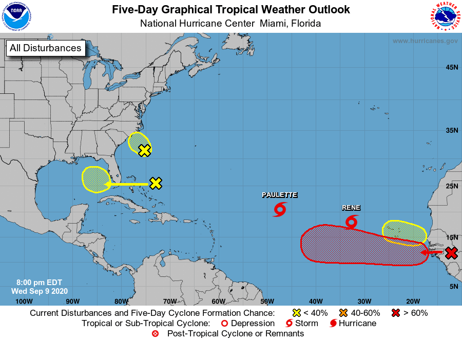
There are three other areas to watch at this time, and at least one of those could become a named storm. Fortunately, the one closest to us off of Cape Fear has not shown signs of organization and just looks to produce some locally heavy rain Thursday into early Friday as it tracks northwest into the area. Another wave could slowly develop over the Eastern Gulf next week. And yet another tropical wave is set to emerge off of Africa by the weekend. At this rate, we will finish up the 2020 list of names before the end of September, and dive into the Greek letters as quickly or even faster than we did in 2005!
You must be logged in to post a comment.