
We hope everyone had a great holiday weekend, and we want to remember the sacrifices made by those who gave their lives to serve this great nation!
As nice as it was to see at least some sunshine for water-logged areas this past weekend, many of us couldn’t shake the recent wet pattern we’ve been in since mid-May, as slow-moving thunderstorms fired up in clusters and dropped locally 2-3 inch per hour rainfall rates. And unfortunately, the news doesn’t get any better as we see yet another surge of tropical moisture coming our way for several more days.
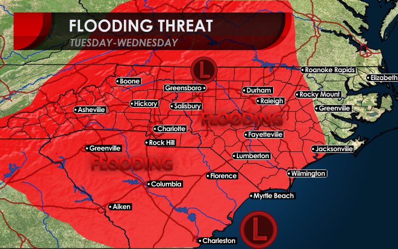
While not very organized, a center of low pressure developing tonight from a Caribbean Sea-based tropical wave will track along the Southeast coast on Tuesday and bring lots of tropical moisture up with it. It’s unlikely to get named, but it will mimic a weaker tropical system as it produces bands of heavy rain and wind gusts of 30-35 mph north and east of its track. The track drenches many in the Low Country starting Tuesday night and then soaks much of the Upstate and North Carolina on Wednesday. After Wednesday night, the low will get absorbed by the next slow-moving storm system tracking northeast from the South-Central U.S.
The map at the top of the page shows the potential track of the low and areas that could receive new flooding by the middle of the week. In addition to the heavy rain expected, some coastal flooding could inundate Charleston Harbor at high tide Tuesday night, and there could be local areas of overwash all the way up to Cape Lookout by Wednesday afternoon. Rivers that are swollen across the region could see additional crests in moderate flood stages by Wednesday and Thursday. Other vulnerable areas include the NW Piedmont and foothills as moisture glides up the east slopes of the Appalachians.
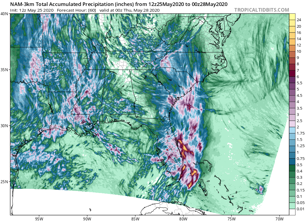
Monday afternoon forecast model rainfall amounts in the graphic below show heavy rain that caused a soaker Monday on the Space Coast of Florida spreading up into the South Carolina Low Country, where 2-3 inches of rain is expected through Wednesday, but potentially higher amounts up into southeastern North Carolina in more concentrated bands of rain. In addition, heavy rain is forecast along and east of the Eastern Continental Divide. There could be a few places both at the coast and in the highlands that end up with additional amounts of 4-8 inches of rain in localized bands of rain through Wednesday night alone!
This pattern of drenching rain could foretell what we expect to be an active tropical season for the Carolinas as long term forecasts look wet up the Southeast Coast this summer. We will highlight details of our summer forecast in next week’s newsletter, available to our subscribers.
We wish we could say the weather will vastly improve behind this system, but the pattern remains unsettled into next weekend, but then a cold front should bring much drier weather by the start of next week.
-CWA
You must be logged in to post a comment.