
Skip to content
Latest
  • Latest 2026-27 Winter Outlook for the Carolinas
  • Winter 2026-27 May Not Be What We Expect in the Carolinas
  • A Drop Down to Normal Just In Time for Fall?
  • Hot September Incoming
  • Single Digits Likely Tonight in the Carolinas
Carolina Weather Authority

Carolina Weather Authority

  • Home
  • Map Wall
  • Home
  • Michael Griffith
  • Page 151

Author: Michael Griffith

I have had a passion for the weather since a very young age and am a degreed meteorologist. I have a Bachelor of Science from Penn State University and a Master's from Plymouth State University. If you ever see me out and about in the Charlotte, NC or Fort Mill, SC area, be sure to say hi!

April 2017 Outlook

March 26, 2017 By Michael Griffith

3-26-2017 Mike Griffith, Meteorologist The beginning of April is looking cloudy, wet, and cool. Rain, heavy at times, will dominate the pattern followed by frequentRead More

Share to inform your family and friends!

  • Tweet
  • Email a link to a friend (Opens in new window) Email

Like this:

Like Loading…

First Named Tropical System in the Caribbean Possible, Could Spell Early Start for Hurricane Season

March 25, 2017 By Michael Griffith

3-25-2017 Mike Griffith, Meteorologist There is a disturbance in the Caribbean, and it will slightly strengthen but will move away from land and will notRead More

Share to inform your family and friends!

  • Tweet
  • Email a link to a friend (Opens in new window) Email

Like this:

Like Loading…

Severe Weather Likely Saturday, Including Tornadoes

March 25, 2017 By Michael Griffith

3-25-2017 If you live anywhere in the yellow, expect severe thunderstorms today (Saturday). This includes large hail and damaging winds, and likely tornadoes. The threatRead More

Share to inform your family and friends!

  • Tweet
  • Email a link to a friend (Opens in new window) Email

Like this:

Like Loading…

Severe Weather Possible Across the South Tuesday Into Tuesday Night

March 20, 2017 By Michael Griffith

3-20-2017 A wave of low pressure develops along the NC/SC border late Tuesday, and could bring severe weather in spots. Pictured is the futurecast radarRead More
Share to inform your family and friends!

  • Tweet
  • Email a link to a friend (Opens in new window) Email

Like this:

Like Loading…

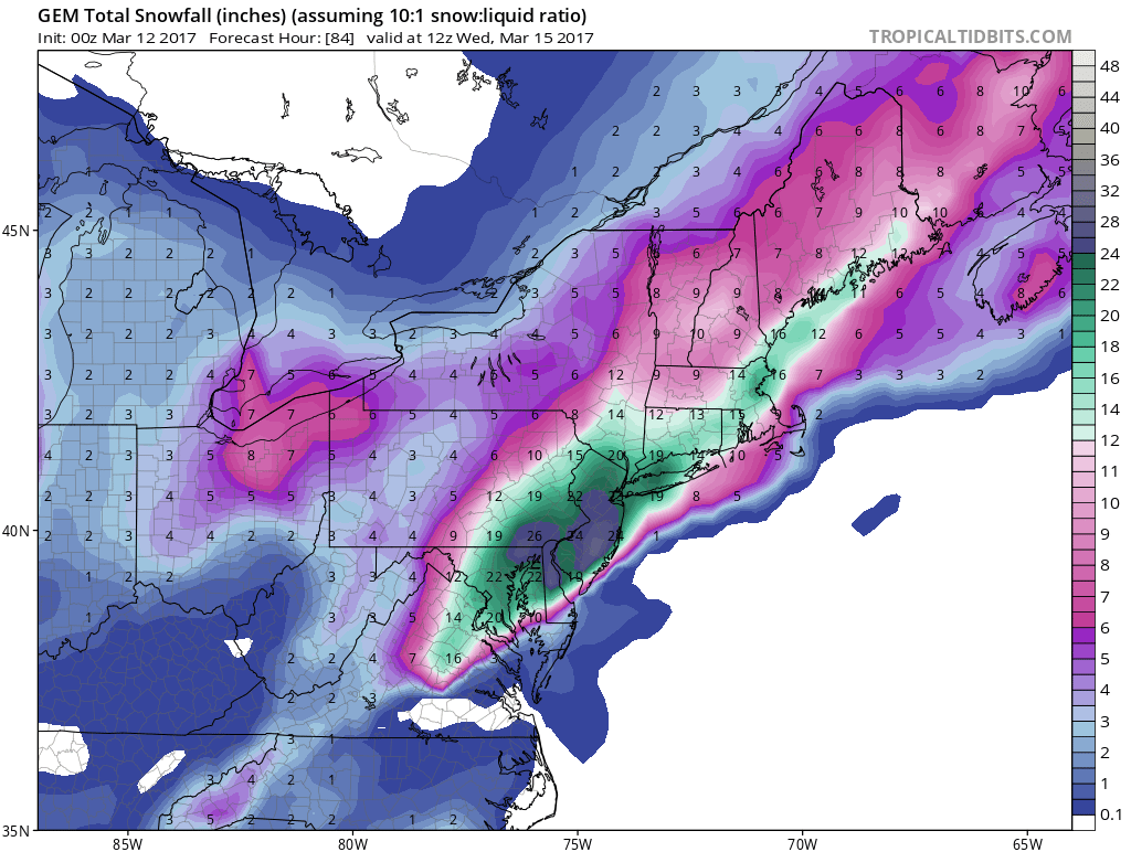
Latest 00Z Comparison of the Canadian vs. the GFS Models and What it Means for the Northeast

March 12, 2017 By Michael Griffith

3-12-2017 Mike Griffith, Meteorologist There is an ongoing debate between us Americans and the Canadians. They think that the hammer now drops over Philly andRead More

Share to inform your family and friends!

  • Tweet
  • Email a link to a friend (Opens in new window) Email

Like this:

Like Loading…

Canadian Model is the Most Believable For Tuesday’s Major Winter Storm

March 11, 2017 By Michael Griffith

3-11-2017 The hammer continues to drop for the Northeast this Tuesday, and the Canadians seem to have a handle on the forecast. We are lookingRead More

Share to inform your family and friends!

  • Tweet
  • Email a link to a friend (Opens in new window) Email

Like this:

Like Loading…

Snow/Sleet for Sunday 3-12 Across Much of NC, Some of SC

March 11, 2017 By Michael Griffith

3-11-2017 Model runs have been consistent with a wintry mix including snow across NC for Sunday. We would advise cancelling any activities due to theRead More

Share to inform your family and friends!

  • Tweet
  • Email a link to a friend (Opens in new window) Email

Like this:

Like Loading…

Game is Still on for the Northeast, DC, with INSANE Snow Amounts For Philly, NYC

March 10, 2017 By Michael Griffith

3-10-2017 The nor’easter for Tues-Weds next week is now looking even more intense than before. Keep in mind that these amounts include sleet and freezingRead More

Share to inform your family and friends!

  • Tweet
  • Email a link to a friend (Opens in new window) Email

Like this:

Like Loading…

Friday Morning System For Philly Looking Light, Despite Heavy GFS Output

March 9, 2017 By Michael Griffith

3-9-2017 Philly’s am commute looks to be messy, but these snow amounts are way overdone. There will not be anywhere near 5 inches of snow.Read More

Share to inform your family and friends!

  • Tweet
  • Email a link to a friend (Opens in new window) Email

Like this:

Like Loading…

Latest 12Z GFS Shows *Frozen Precipitation* for NC and part of SC

March 9, 2017 By Michael Griffith

3-9-2017 This morning’s run of the GFS is showing a winter storm moving across NC on Sunday, starting Sunday morning. One thing to keep inRead More

Share to inform your family and friends!

  • Tweet
  • Email a link to a friend (Opens in new window) Email

Like this:

Like Loading…

Posts navigation

Older posts
Newer posts

Like us on Facebook!

Like us on Facebook!

Active Alerts

Current NWS Watches, Warnings, and Advisories

7-Day Tropical Outlook

Today’s Severe Threat

Follow Us

  • Facebook
  • X
  • Instagram
  • YouTube
© 2019 Best blog in 21st Century
Powered by WordPress - Lekh by ThemeCentury
Carolina Weather Authority
Loading Comments...

You must be logged in to post a comment.

%d