
In a rather unexpected turn of events, tropical storm Dorian continues to gain more and more interest, as the cyclone continues to trend north and east on the forecast computer modeling. This carries significant implications for areas that originally had no expectations of any impact from Dorian. Earlier projections had Dorian’s path more southwest into Puerto Rico and into the Caribbean Islands where it was expected to diminish with extensive land interaction.
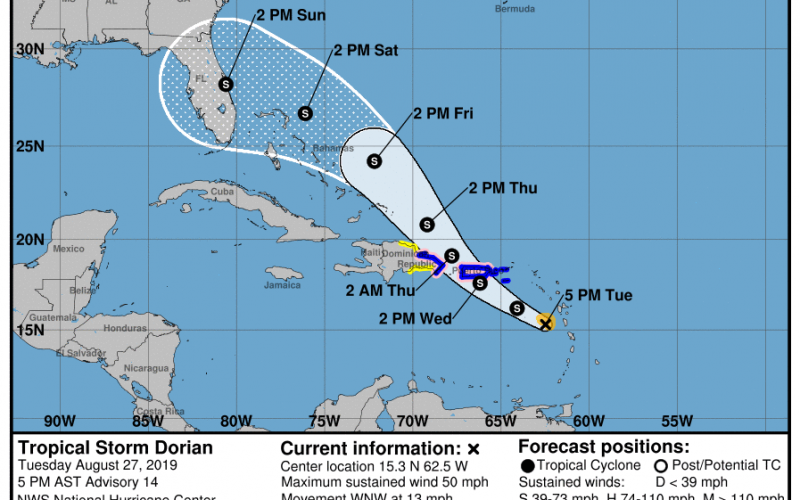
Since then we’ve seen a notable trend north and east on the modeling. For now, it looks as though Puerto Rico is still at risk of seeing a tropical system by tomorrow, but the risk is decreasing for a track through the Caribbean islands, and increasing for portions of the Southeast US. Modeling now takes Dorian further east away from a lot of the islands, adding intensification over the open waters. Modeling disagrees on whether Dorian stays within tropical storm classification , or intensifies to a hurricane. Regardless of exactly how much intensification transpires, much of the model consensus now agrees on a track over the Bahamas by Friday and a landfall in Florida by this weekend. We can see all of this reflected in the latest outlook from the National Hurricane Center:
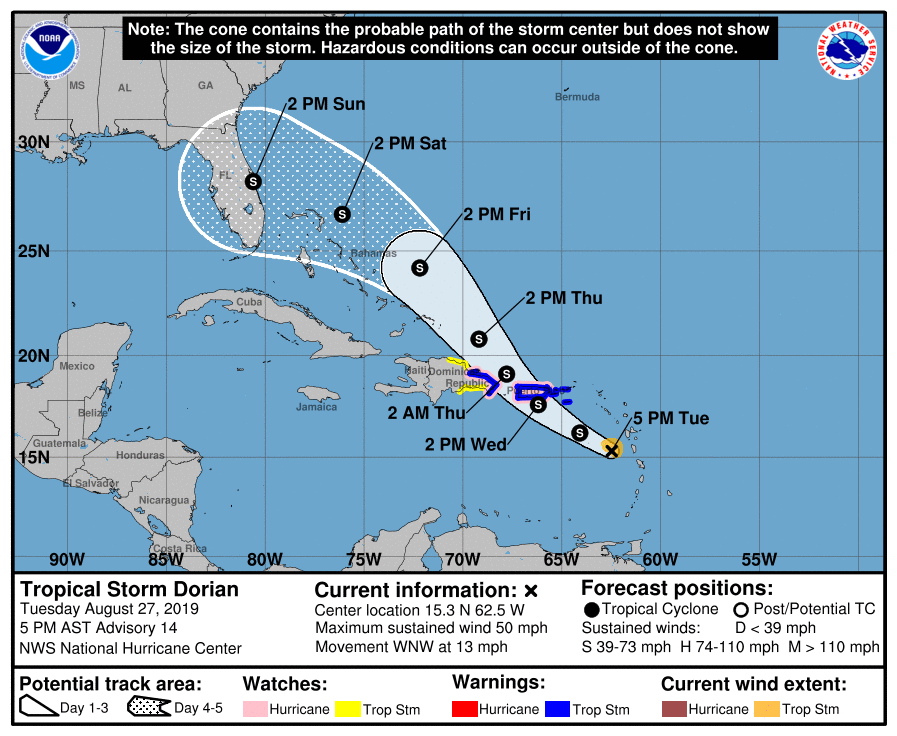
The Bahamas need to begin preparation for tropical storm conditions by later this week. Florida needs to begin preparation for what could be a tropical storm or even possibly a hurricane potentially land-falling this weekend from Saturday into Sunday.This means potentially high winds, heavy rainfall, storm surges, and flooding to parts of Florida this weekend. There can definitely still be changes, but this is becoming an increasingly likely scenario, and it should not be ignored for anyone in that area.
What is an alternative? This is where assumptions and curiosities come into play for the possibility of Georgia and/or Carolina impact. If we take a look at our 500 millibar height pattern, we can see the attributes of it dictating the path of our tropical cyclone as it makes its way into the Southeast. Let’s take a look at the European ensemble modeling for this weekend:
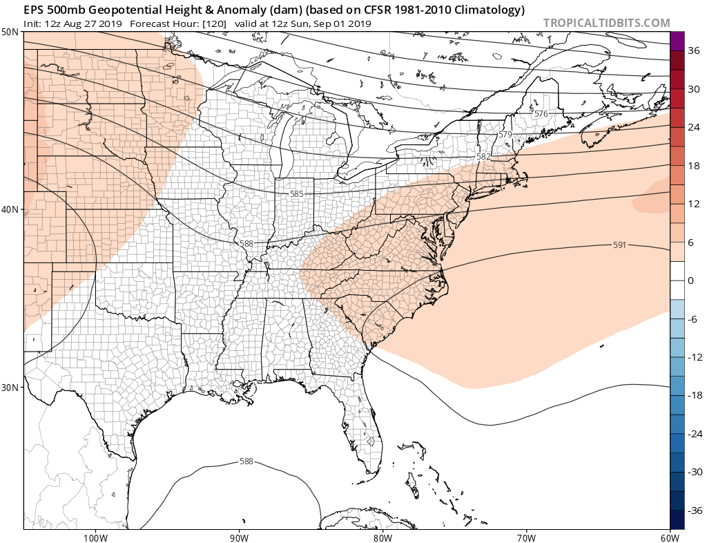
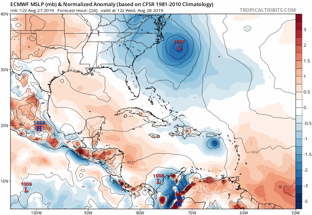
This weekend, it appears as though a ridge of high pressure resides over the East Coast. But how strong is that ridge? The strength of that ridge will determine the course of Dorian as it enters the Western Atlantic waters just off the Southeast Coast. A more expansive ridge would likely lead to a Florida landfall, potentially followed by a westward route into the Gulf Of Mexico placing those areas at risk. The cyclone would weaken some over Florida, but possibly re-intensify in water near the Gulf, threatening various regions in that vicinity of the Atlantic. We can see that solution reflected in today’s 12z run of the operational European model which follows a similar path of a lot of other modeling:
To be clear, as this is written Tuesday evening, the general modeling consensus for Dorian is to keep it SOUTH of the Carolinas . However, we are still several days out, and we have seen consistent northeast trending on the modeling over the last few days, indicating that if this continues, Georgia and the Carolinas may not completely be out of the woods. The most recent evening run of the operational GFS has actually taken a significant jog north from the afternoon run, but you should know that it is a huge outlier at this time in comparison to the majority of other modeling, and for that reason I choose not to show it here. We don’t want to hype any one run of a forecast model, as that tends to be rather unreliable at this range, but we do want to keep an eye on future modeling trends. Here is the latest 18z guidance from several models for Dorian courtesy of Levi Cowan at Tropical Tidbits:
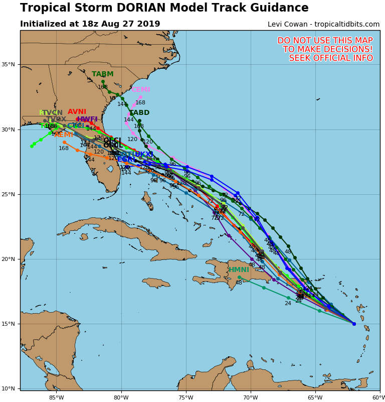
As you can see the majority consensus from most modeling is AWAY from the Carolinas, but current guidance can and will change to some degree. How exactly it changes remains an uncertainty at this time. As many forecasters have already designated, and often do in the early stages of a noteworthy tropical threat, Georgia and the Carolinas should be “aware” that there is currently a very slight chance that we could be dealing with something tropical within the next week. Alterations to plans or excessive preparation is unnecessary at this time, but it would be wise to stay tuned for further updates in the days ahead, as this situation continues to unfold, especially with the holiday weekend approaching. Stay with us here on the site and on our Facebook and Twitter pages for the latest tropical information. Mike and I will be watching very closely, and do our best to keep you informed on significant details as they arise heading toward Labor Day Weekend. Also make sure to check out our models page. There you can find the latest tropical outlooks and links to important model guidance for Dorian.
Have a great evening and stay tuned.
-Jesse
Carolina Weather Authority
You must be logged in to post a comment.