
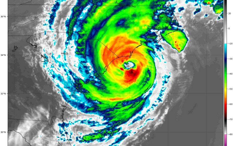
Dorian continues to batter the Carolinas this evening as a category 2 hurricane with the eye wall just 40-50 miles off the Carolina coast between Northeast South Carolina and Southeast North Carolina. Already, notable damage has been witnessed in portions of Eastern North and South Carolina from high winds, flooding, and a rather excessive amount of tornado activity, especially for places like Myrtle Beach and Emerald Isle.
Northeast South Carolina will continue to experience high wind gusts into tonight with gusts up to 60 mph or more in spots, as well as torrential rainfall and flooding, especially near the coast where storm surges are prevalent. Conditions should start calming down later tonight, but flooding impacts may linger awhile longer.
Dorian will continue to move northeast and very close to the coast, but potentially making landfall in the Outer Banks sometime overnight tonight into early Friday morning. Eastern North Carolina will continue to see a sporadic tornado risk linger into early Friday morning, especially closer to the coast. Winds will increase as the eye approaches the Outer Banks and regardless of whether Dorian hugs the coast or actually makes landfall, wind gusts could soar to as much as 80-90 mph in many areas, with localized gusts up to 100 mph not out of the question. Numerous areas of damage to trees, structures, and power lines is expected with power outages numerous, particularly near the coast. Storm surges will also continue to be rather robust, and coastal flooding is going to be a significant issue heading into tomorrow. There will also be areas of flash flooding inland from excessive rainfall, where some areas could tally several inches of rainfall through tomorrow.
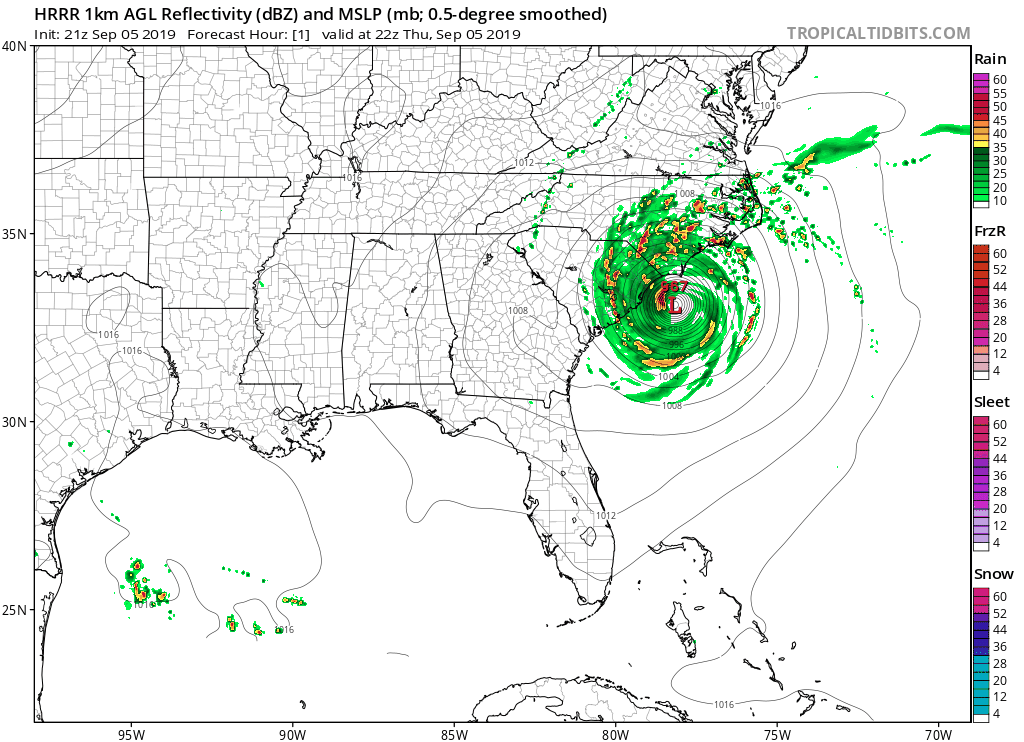
Dorian will batter the Eastern Carolinas into tomorrow, but the tornado threat will gradually diminish tomorrow with continued wind gusts and flooding the main issues. A weakening to a category 1 hurricane is possible tomorrow, but shouldn’t lessen any cautionary thinking as any hurricane is still a dangerous storm. Dorian should push east of the Carolinas by sometime Friday afternoon. Here’s the latest progression from the HRRR model as of the 5:00 PM run:
If you didn’t evacuate, please take Dorian seriously. There has already been numerous areas of wind, flood, and tornado damage today from Dorian today and there will continue to be so please take all necessary precautions, and if you don’t have to go out, please do not! Stay put and batten down the hatches while you still can. Stay tuned for the very latest in Dorian coverage on Facebook and Twitter, and here on the site. Also follow along with our models page right here on the site where you can personally track Dorian’s evolution: https://carolinawxauthority.com/models/
Also, if you have a battery operated NOAA weather radio, that would be great to utilize. You can listen in for significant watches and warnings from your local National Weather Service, should your power go out and you lose cellphone service.
Stay safe and stay tuned.
-Jesse
Carolina Weather Authority
You must be logged in to post a comment.