
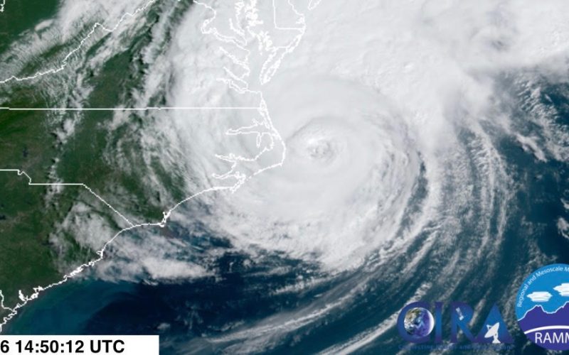
At 8:35 AM this morning, Dorian made landfall on the Outer Banks of North Carolina as a category 1 hurricane with sustained winds of 90 mph. Dorian was remained slightly offshore for much of its time battering the Eastern Carolinas, but an Outer Banks landfall is the destination our modeling has pointed to for several days, and indeed we saw that verify earlier today. This makes the fourth landfall Dorian has made since its origin in the Atlantic with other landfalls decimating various islands in the Bahamas.
#Dorian has made landfall over Cape Hatteras, North Carolina at 835 AM EDT. Maximum sustained winds were estimated near 90 mph (150 km/h), and the estimated minimum central pressure was 956 mb (28.23 inches). More: https://t.co/tW4KeFW0gB pic.twitter.com/IgOso4dvvs
— National Hurricane Center (@NHC_Atlantic) September 6, 2019
And now the cleanup begins. Residents of the Eastern Carolinas that have evacuated, particularly near or along the coast, will likely return to considerable areas of damage from high wind gusts, some isolated areas of damage from several tornadoes, and flooding, inland and coastal.
Any inland flash flooding should be letting up, though some areas may have to contend with some flood damage. Coastal flooding continues to be the more prominent issue today from dangerous storm surges, especially near the Outer Banks where a Flash Flood Emergency remains in effect for Hatteras and surrounding areas from the National Weather Service, which states that flood levels are comparable to that of Hurricane Matthew back in October of 2016.
Flash Flood Emergency continues for Buxton NC, Ocracoke NC, Avon NC until 12:00 PM EDT pic.twitter.com/naZ3IpnAmo
— NWS Newport/Morehead (@NWSMoreheadCity) September 6, 2019
Check out these videos from the National Weather Service in Newport/Morehead City of flooding on the Outer Banks today:
We're getting some pictures and videos of the severe flooding due to storm surge on the Outer Banks. This is Ocracoke, NC. Our hearts go out to ALL impacted by #Dorian. #nws pic.twitter.com/OAVxjJkUjj
— NWS Newport/Morehead (@NWSMoreheadCity) September 6, 2019
MORE Dramatic video out of Ocracoke, NC. Storm surge is ONE of many threats from ANY tropical cyclone. Other hazards include flooding, wind, tornadoes and rip currents! Don't focus on the category! Our hearts go out to ALL impacted by #Dorian. #nws pic.twitter.com/Q6ihg37IyI
— NWS Newport/Morehead (@NWSMoreheadCity) September 6, 2019
This is expected to linger into most of today before beginning recession later today into tomorrow as Dorian’s final remnants push northeast into the Atlantic basin by later this afternoon.
Dorian left considerable damage in some areas from numerous tornadoes, some strong, on Friday in many locations of the Eastern Carolinas. Here’s a look at tornado reports from the Storm Prediction Center yesterday:
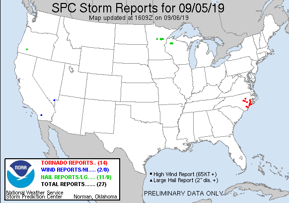
Although not shown, portions of Eastern South Carolina also witnessed some tornado activity, such as Myrtle Beach. The most significant tornado of Thursday was likely in Emerald Isle, North Carolina. The National Weather Service in Newport/Morehead City, North Carolina tweeted some photos of the damage in Emerald Isle yesterday following the tornado touchdown there:
Getting some pictures into the office of the damage in Emerald Isle, NC caused by a tornado around 9 AM this morning. We thinking of those that have suffered damage. PLEASE have multiple ways to receive warnings the next 24 hours! pic.twitter.com/UbU68ww4V4
— NWS Newport/Morehead (@NWSMoreheadCity) September 5, 2019
Fortunately for residents of the Eastern Carolinas, cleanup will be accompanied by calmer weather, as no significant weather systems are expected to impact the Carolinas for the next several days.
Thank you for your support of Carolina Weather Authority during the tracking evolution of Hurricane Dorian. We strive to keep you informed and up to date on the latest significant information here on the page, as well as our social media coverage on Facebook and Twitter. We are merely coming up on the peak of the hurricane season, and we have a long way to go, so stay with us as we track each individual tropical wave and cyclone over the next couple of months. Hurricane season officially ends November 30th, so keep that in mind.
Don’t ever let your guard down this time of year. As we learned with Dorian, seemingly feeble tropical cyclones initially expected to be little more than a nuisance, can quickly morph into record-breaking monsters. Much of Bahamas are left in utter devastation at this moment from a storm that was originally expected to be a weak category 1 hurricane and track well to their Southeast. This is why we continue to keep a close eye on every wave in the Atlantic, for it may have a few more surprises up it’s sleeve this season.
Our thoughts and prayers go out to all of you impacted by this event, and we hope you will stay tuned for more forecasting information and storm coverage following this event, from Carolina Weather Authority.
Satellite Imagery Courtesy Of The Regional and Mesoscale Meteorology Branch (RAMMB) of NOAA/NESDIS
-Jesse
Carolina Weather Authority
You must be logged in to post a comment.