
FROST ADVISORIES AND LOCALIZED FREEZE WARNINGS IN EFFECT FOR WESTERN NORTH CAROLINA
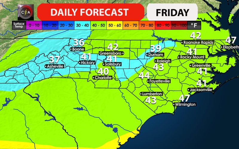
Temperatures will take a considerable tumble tonight behind our departing cold front with the chilliest air of the season thus far.
The National Weather Service in Greenville-Spartanburg, South Carolina has issued a Freeze Warning for Yancey and Mitchell counties along the spine of the Blue Ridge from midnight to 9:00 AM Friday. These counties could experience damage to crops, vegetation, and possibly even unprotected outdoor plumbing. Elsewhere across the western mountains and foothills, Frost Advisories are in effect from 2:00 AM to 9:00 AM Friday, and necessary precautions should be taken to protect any sensitive outdoor vegetation.
Chilly temperatures will be widespread with areas outside of the advisory areas still experiencing temperatures in the upper 30’s and 40’s depending on your location, with 50’s much further south and east. Make sure to grab the scarfs and jackets on your morning commute. Temperatures will moderate slightly by afternoon, but only to the 60’s for most areas with 50’s in the higher elevations.
Even colder weather looms in the long range. Read all about that in our latest outlook released on Tuesday. Stay up to date with all the latest here on the site and social media including tropical trouble this weekend, possible severe weather next week, and late month significant cold! We’ve got a lot going on and will keep you informed of the latest!
-Jesse
Carolina Weather Authority