
A ridge of high pressure centered over the Mid-South will continue to bring relentless heat to the Southeast and Mid-Atlantic this week with high temperatures reaching well into the 90’s with heat indices surpassing 100 in many locations. An occasional hit or miss heavy shower or storm is possible on some afternoons and evenings, but widespread beneficial rainfall is not expected. The ridge will begin to lift northward next week and this will allow for more showers and storms to be around, but conditions will remain very warm to hot, and humidity will just become more excessive.
For those of you waiting for a sustained autumn-like pattern, you’re just going to have to keep waiting, because it’s unlikely that it will arrive this month. Can we squeeze in a brief cold front or two? Maybe. But the only signal of this seems to be in the fantasy range of the modeling, (beyond the 10 day range). If we see more consistency in this idea a few days from now than maybe we can start talking more seriously about an autumn-like cool snap. Even with that in mind, a sustained pattern change doesn’t seem likely any time soon. Take a look at the GEFS ensembles out through day 10:
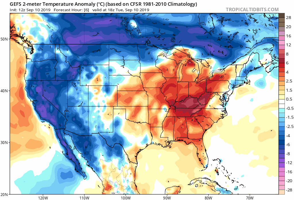
The orange and red colors represent temperatures above normal, while blue and purple colors indicate temperatures below normal. As you can see, cooler than normal temperatures are mainly limited to the north and west over the next 10 days.
With the extended ridging setting up over the North Atlantic into the Eastern United States, this brings about two occurrences in the weather pattern that are very unwanted and very unpopular this time of year. One of them is an extension of summer when autumn should be setting in. The other is a like an open door and welcome mat for tropical cyclones to march right up to the US mainland from the Tropical Atlantic and cause problems for the Gulf Coast and/or the East Coast.
The saying “ridge over troubled waters” often refers to the pathway tropical cyclones are forced to take from the Tropical Atlantic toward the US due to the strong ridging to their north that restricts most re-curving scenarios from being possible. The disturbance has nowhere to escape, so it heads right for the Gulf or East Coast. Placement, timing, and strength of troughs and ridges further dictate the pathway of the disturbance from there so each one can be different.
The tropics remain very favorable for development the further we head into September and even into October, and this pattern set up between the Atlantic and the Eastern US is recipe for trouble sooner or later.
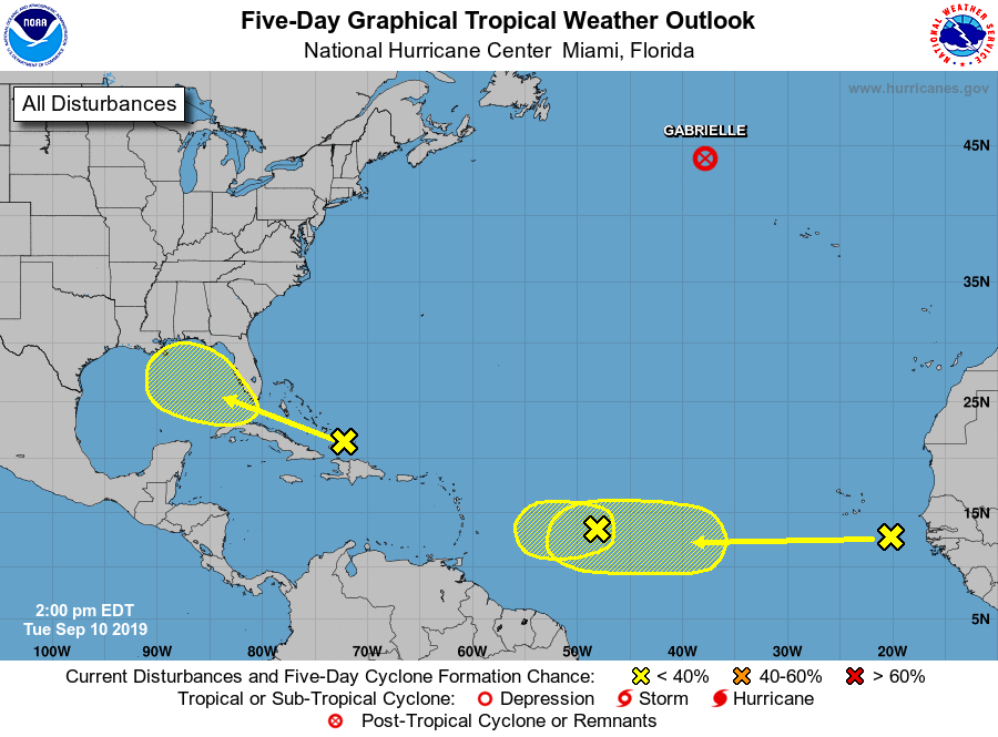
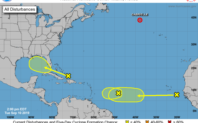
Currently, we have some mischief showing up on the latest outlook from the National Hurricane Center. These are tropical waves of showers that present a slight chance of developing into an actual cyclone, but are unlikely to at this time. The feature you see headed for the Gulf of Mexico is likely to stay weak and disorganized, but there is a slight chance this develops into a tropical cyclone. Furthermore, models indicate that this feature could bring much needed rainfall to parts of the Southeast early next week. The second and third features are currently given a 20% probability of developing into a cyclone within the next 5 days. One of them is located several hundred miles east of the Lesser Antilles while another is located just east of the Cabo Verde Islands and just west of the African coast. These may be something to watch over the next several days as the modeling suggests these areas of mischief will move westward and one of them could end up really strengthening upon reaching the Caribbean over the next several days. Check out this cluster of potential low locations showing up on the European Ensemble for this time next week:
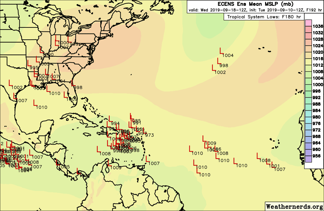
Right now there seems to be some signaling from much of the modeling, (including the Euro ensembles above) for a *possible* system of concern around the middle of the month developing into a cyclone, potentially intensifying in the Caribbean, and working it’s way westward. Now will something actually develop? Where exactly will it go? Will it make it to Southeast US? If so, will be it be the Gulf or East Coast, and will the Carolinas be impacted? These are all just questions right now.
There is currently no forecast of any significant tropical cyclone to impact anyone in the Southeast, but what we can tell you is that the risk of a tropical cyclone impacting somewhere in the US is rather elevated heading further into this month and even into October.
Make sure to stay tuned to Carolina Weather Authority site for the latest, as well as our Facebook and Twitter pages. Also be sure to check out the new models page on our site! It’s loaded with brand new material such as forecast models and maps that you can use to follow along with each tropical threat and other significant weather at your personal convenience.
Have a great night and take care.
-Jesse
Carolina Weather Authority
You must be logged in to post a comment.