
To start, a lot has changed since yesterday. The NAM does not have monstrous totals for Central/Western NY anymore, but does still have heavy accumulations in the area. GFS is starting to see some heavy accumulations into the Hudson Valley and Catskills, and the Euro is jumping on board with the NAM. Before we get into any model analysis on this storm let’s take a look at the current observations and where the storm is right now.
Currently across the Northeast we have temperatures in the 50s and 60s, and if I were to ask you if we are to get any snow on Friday we would all be like no way, oh but yes way. So let’s take a look currently where our storm is right now and what other factors are going into making a potential blockbuster event for winter 17-18.
SPC Current Surface Analysis:
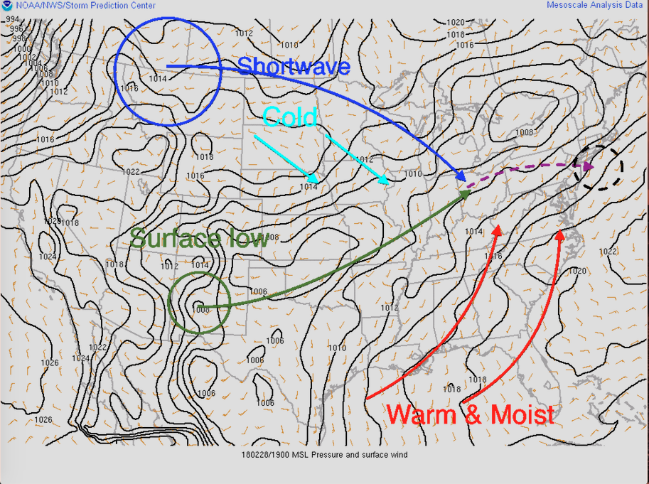
So let’s begin, before we get to all the nitty gritty details let’s start small. Notice the the green circle, that is where our surface low pressure system is located right now. Secondly, notice the larger blue circle, that is our shortwave energy that will inject the cold air needed for snow into our upcoming nor’easter. Again, before we dive any deeper I want to take a look at some satellite images to really make sure the locations of our pieces are where they are.
COD Goes 16 Upper WV Imagery:
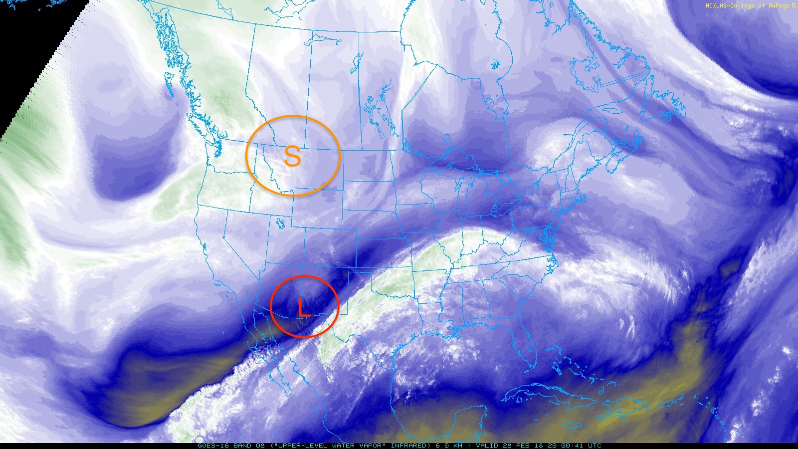
Satellite image does agree with surface analysis where our two pieces of energy are, low pressure (L) in the desert Southwest and our shortwave (S) beginning to force its way down into the lower 48. Now, I will bring back the first image so we can dive right into the details.
So we now have confirmation on where our two main sources of energy are, and that will help us understand model runs and allow us to make conclusions, so let’s begin. Our surface low will move northeastward through the center of the country and into the Ohio River Valley. Our shortwave energy will move eastward until the surface low basically absorbs and takes in that energy. When the surface low takes in the shortwave the energy from he shortwave will allow the upper level trough to dig forcing the energy to re-establish itself along the coast. Also, as our surface low cuts across the lower 48 it will be sucking in warm and moist air from the Gulf of Mexico and along with the shortwave cold air will be injected for many places to receive snow which can be heavy for some.
Another aspect to this storm that was mentioned in my last article is the huge Greenland block. This huge block allows the storm to move very slowly and maybe even stall our along the coast therefore enhancing snowfall amounts, especially for the coastal areas where it transitions to heavy wet snow.
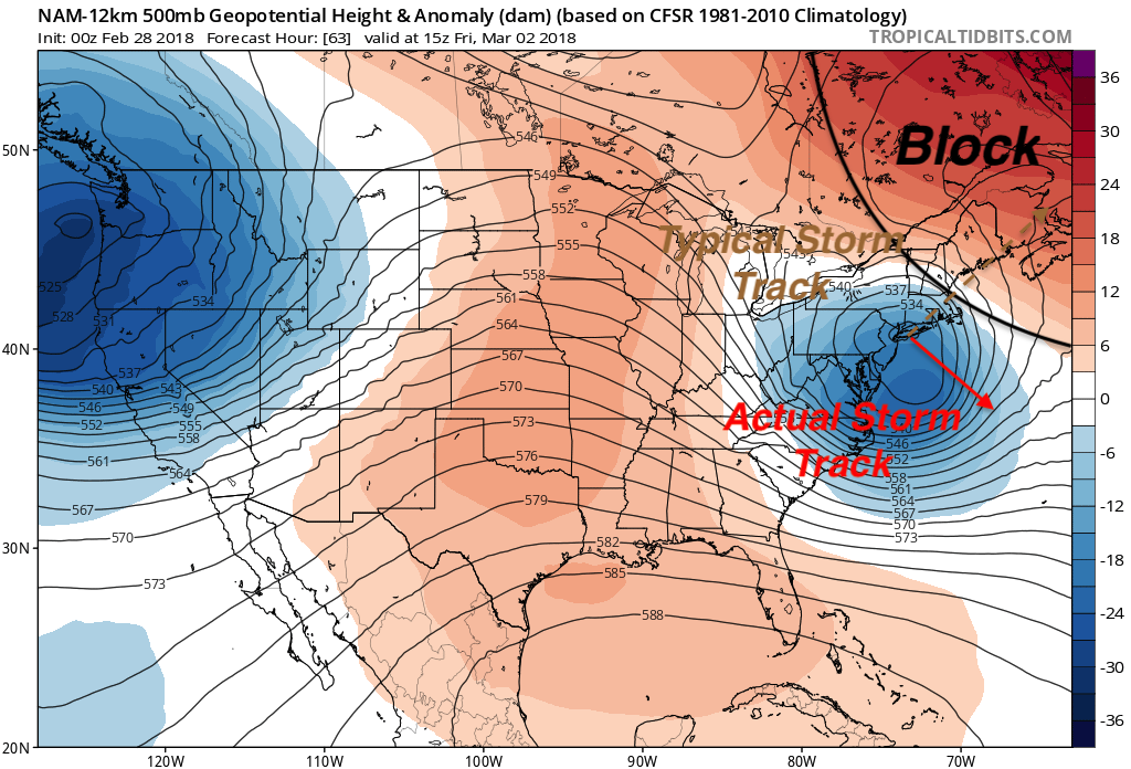
Going back to the image from last nights article, the Greenland block is clearly visible. Typically, a storm like this would take a northeasterly track and move into Nova Scotia rather quickly, but because of the block our system will try to move north and east yet the block will suppress its wanted motion which will slow it down and maybe even make it stall. Being that our storm can not move northeast, the only way it can move out of the area is when it slips underneath the block which is why the track calls for it to move southeast once it reestablishes along the coast.
Finally, one thing we need to watch is how strong and the number of thunderstorms that flare up in the South-Central US today because due to their latent heat release, it will have an effect on the storm track and the precipitation field. More on this stormwater on today or tomorrow and a snowfall map to get you prepared accurately.
-Alex B
You must be logged in to post a comment.