
EL NINO WATCH
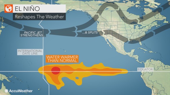
The NWS is currently in an El Niño Watch status. But what exactly does that mean for us here in the East Coast? What conditions can we expect for the hurricane season, fall, and winter? El Niño is defined as a pool of warmer than normal ocean water temperatures in the Pacific along the Equator. This ultimately affects the jet stream and our weather here in the US.
IMPACTS ON THE HURRICANE SEASON
The Pacific is already off to an active start with multiple named storms. This is likely due to the weak El Niño that has formed, which is essentially causing the air to rise over the Southern and Eastern Pacific. This is what hurricanes need to form, as they thrive on unstable air and warmer waters. However, when the Pacific is active, the Atlantic is usually not as active. Thus, we can expect a quieter hurricane season than last year. Although, it only takes one major hurricane to cause serious impacts, so resident near the coast should have a plan in place.
IMPACTS ON UPCOMING WINTER
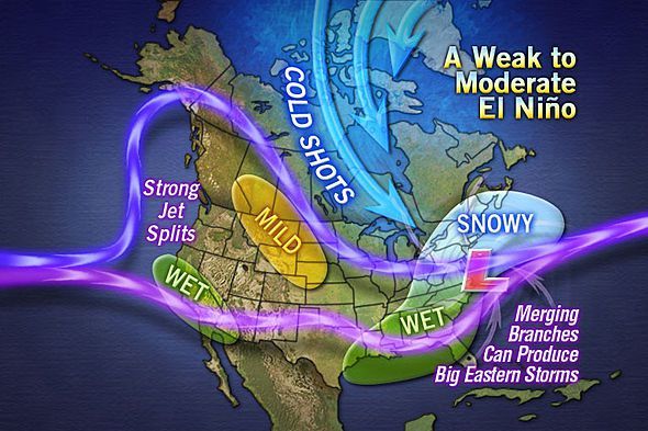
A weak to moderate El Niño will likely have impacts on winter patterns here in the East. However, ENSO conditions are only one factor in determining the overall winter pattern. One possibility is more frequent East Coast storms, and wetter than usual across the South. The Northeast could be in for above normal snowfall. This does not necessarily mean that the South will have above normal snows, but rather it could be warm and wet. Rain could be more frequent than usual.
Continue to follow us here at East Coast Weather Authority for all the long-range updates, and please share, thank you!
You must be logged in to post a comment.