
Good afternoon everyone!
We have had a TON of new followers from Southern New England recently follow East Coast Weather Authority, and it is very important to get you the latest information on the snow event taking place Wednesday. Please make sure to like, comment, share, and invite your family/friends to our page, where they will get updates of storms and lots of content!
Snow will continue to move into the area overnight, with snow impacting the morning commute. The morning commute will be UGLY in Southern New England. Please plan to leave a few minutes early and drive cautiously on the roadways, as they are expected to be slick.
The forecast has remained unchanged for the most part in western Massachusetts. Still a relatively good snowstorm for western CT/western MA, where the expectation is 4-8 inches, with some isolated spots at 10″+. However, where the forecast has changed is into eastern CT, Rhode Island, and out on the Cape.
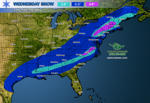
Models consistently pegged the area for 4-8 inches prior to Tuesday. Recent morning and afternoon data show that warmer air will work its way into the storm, allowing for mixed precipitation to fall earlier than expected. The snow/rain mix line has moved to the north, which means the areas south of South and East of Putnam, CT and Woonsocket, RI can expect 1-3″ of snow. (This snow enthusiast is a little bummed).
We will continue to monitor the event for you, and if any changes occur, we will update all of our followers!
Stay safe everyone, Happy Hump Day tomorrow!
-Matt
You must be logged in to post a comment.