
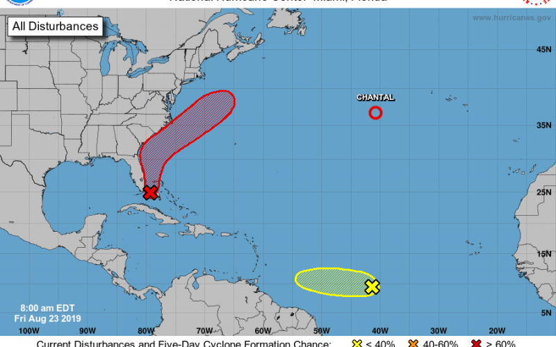
We’re keeping a close watch on an area of low pressure located east of the Florida Keys and the southeastern coast of the Florida peninsula. Currently, this system is generating nothing more than cloudiness and showers, but is expected to likely intensify to a tropical depression as it moves northeastward this weekend, just off the southeastern coast of the United States. The National Hurricane Center’s latest probability of that occurring within 48 hours is at 40% with formation probability within 5 days at 70%. If in fact there is formation, this tropical cyclone would receive the name “Dorian”.
What does this mean? Well fortunately we shouldn’t expect anything too significant in the event of a tropical depression. A tropical depression carries maximum winds of 39 mph or less, and since our forecast modeling indicates that this system will remain somewhat off the coast, wind should be even less of an issue. Some localized minor impacts to the Carolinas may eventually occur however, with tropical moisture surging northward to increase our rain chances later this weekend and early next week. Heavy rainfall would potentially be imminent, as well as rough surfing conditions to some of our coastal regions into early next week, as the system treks northeastward.
Here’s a projection of the potential evolution of this system from our GFS model:
While we do not currently anticipate significant impacts from this potential depression, it serves as a reminder that our season of tropical activity is nowhere close to over, and perhaps a sign that the Atlantic might be waking up. Additionally, yet another item of interest lingers out in the Atlantic on the latest tropical outlook from the National Hurricane Center to further prove that point. We’ll be watching.
Make sure to stay with Carolina Weather Authority for the latest tropical information updates, here on the site, and our social media pages on Facebook and Twitter. You can also find access to the tropical outlook and modeling shown here, and more available on our models page. There you’ll find severe weather and tropical outlooks, and links to pages that include the GFS model (shown above), as well as other operational, short and long range, and ensemble modeling. Check it out here >>> http://carolinawxauthority.com/models
-Jesse
Carolina Weather Auhtority
You must be logged in to post a comment.