
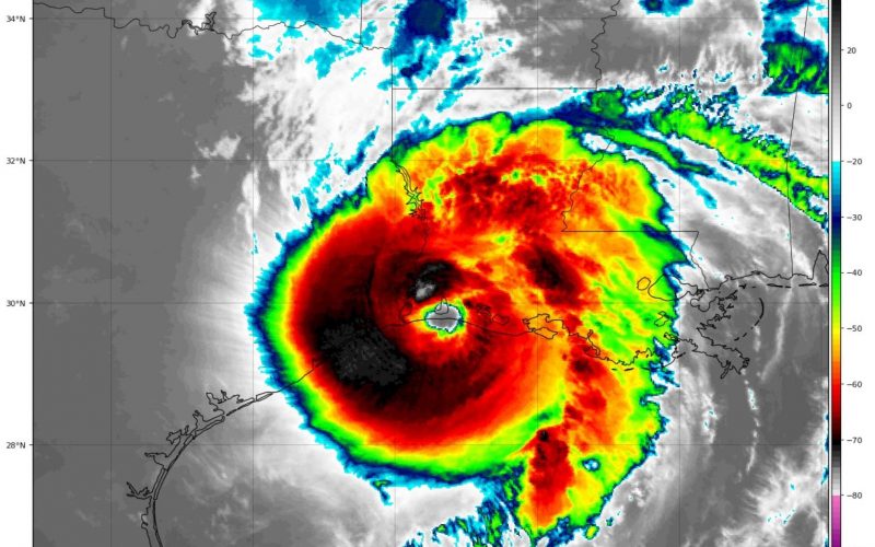
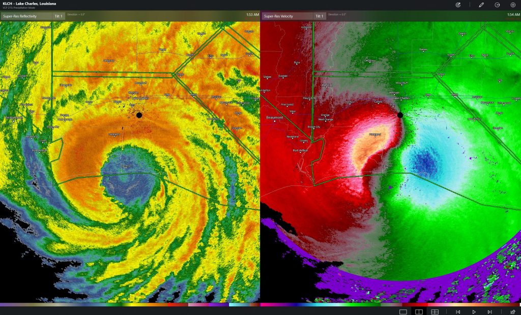
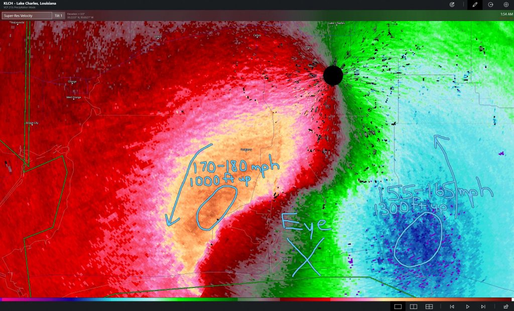
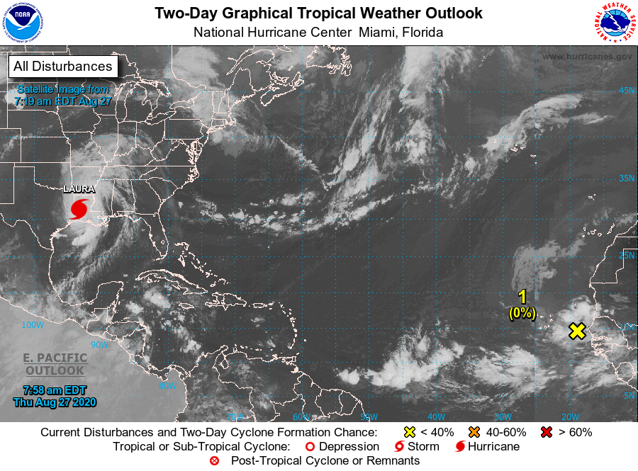
Hurricane Laura intensified rapidly in the 36 hours leading up to landfall in Cameron, Southwestern Louisiana, just before 1 a.m. CDT as a strong Category 4 hurricane, which may have briefly touched Category 5 status in the 6 hours leading up to landfall. Laura was the strongest hurricane to ever hit Louisiana, and one that we predicted would be the first major hurricane of the 2020 Atlantic season well before official forecasts showed that.
While Houston and even Beaumont were fortunate enough to be spared the worst, residents in Louisiana hit hard by Hurricane Rita in 2005 and Hurricane Ike in 2008 were once again dealt an incredible blow, leaving the few residents left with nothing standing. Laura’s intensification was hinted at by regional hurricane models such as the HWRF, but she overachieved. We boldly made the prediction that Laura would be a Category 5 storm near landfall in Louisiana four days before she did, though our track needed to be adjusted almost 100 miles to the west. That forecast was based on the storm trending west and spending a lot of time over warm bath water in the central and northwestern Gulf, and the obvious sign that shear was weakening. Maybe one day the models we trust so much will do a better job forecasting rapid intensification, since it has been occurring a lot in recent years.
Laura was yet another hurricane that intensified rapidly before hitting land. The list of storms doing so is alarming in just the last 4 years. Hurricane Harvey did so in the western Gulf before hitting the middle Texas Coast as a Category 4 hurricane in August 2017. Then a week later, Category 5 Hurricane Irma did so east of the Virgin Islands, and later struck southwest Florida as a Category 3 hurricane. A couple weeks after, Hurricane Maria strengthened to a Category 5 hurricane while approaching the northern Leeward Islands and held that intensity before wiping out Puerto Rico. The next year, Hurricane Michael intensified rapidly into a strong Category 4 hurricane and made landfall near Panama City, Florida in October 2018. He was later analyzed to be a Category 5 hurricane after post-storm analysis. And then last year, Hurricane Dorian rapidly intensified east of the northern Bahamas, striking Abaco and Grand Bahama as a strong Category 5 hurricane.
Six hurricanes have explosively developed before hitting land in the last 4 years – a sign of the unpredictability of the times. In most cases, these occurred less than 48 hours before landfall, catching many, and we mean many, off guard! We believe this is the new normal, and 2020 is far from over!!!
Residents of western Louisiana have a major, disheartening task of cleaning up from their worst hurricane ever in the coming weeks. They may not be finished for the year with hurricanes. Now we track Laura’s weakening circulation as she is expected to weaken to below hurricane strength this afternoon over far northwestern Louisiana and southern Arkansas, bringing destructive winds, flash floods, and tornadoes well inland to as far north as southeastern Missouri tonight and tomorrow morning. Laura should be a tropical depression by tomorrow night over the Tennessee Valley and Kentucky. But, we need to watch closely in the Carolinas, as a strong trough and cold front will pick up Laura’s remains and help her to re-intensify into an extratropical storm while over land (likely centered over Virginia) during the day on Saturday!!! Some models even have Laura becoming a tropical storm again as she pulls away from the Northeast Coast on Sunday.
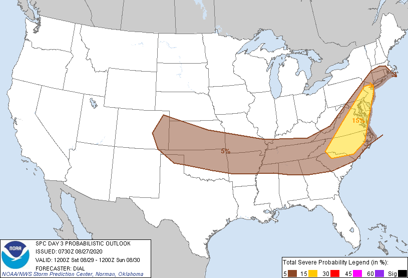
There is some indication on short range models that storms could produce damaging winds and isolated tornadoes in the area circled in yellow on Saturday. Upon closer analysis, the central and northern part of the state could have tornado-warned storms in the afternoon Saturday, including the Charlotte area, Triad, the Triangle, and southeastern Virginia.
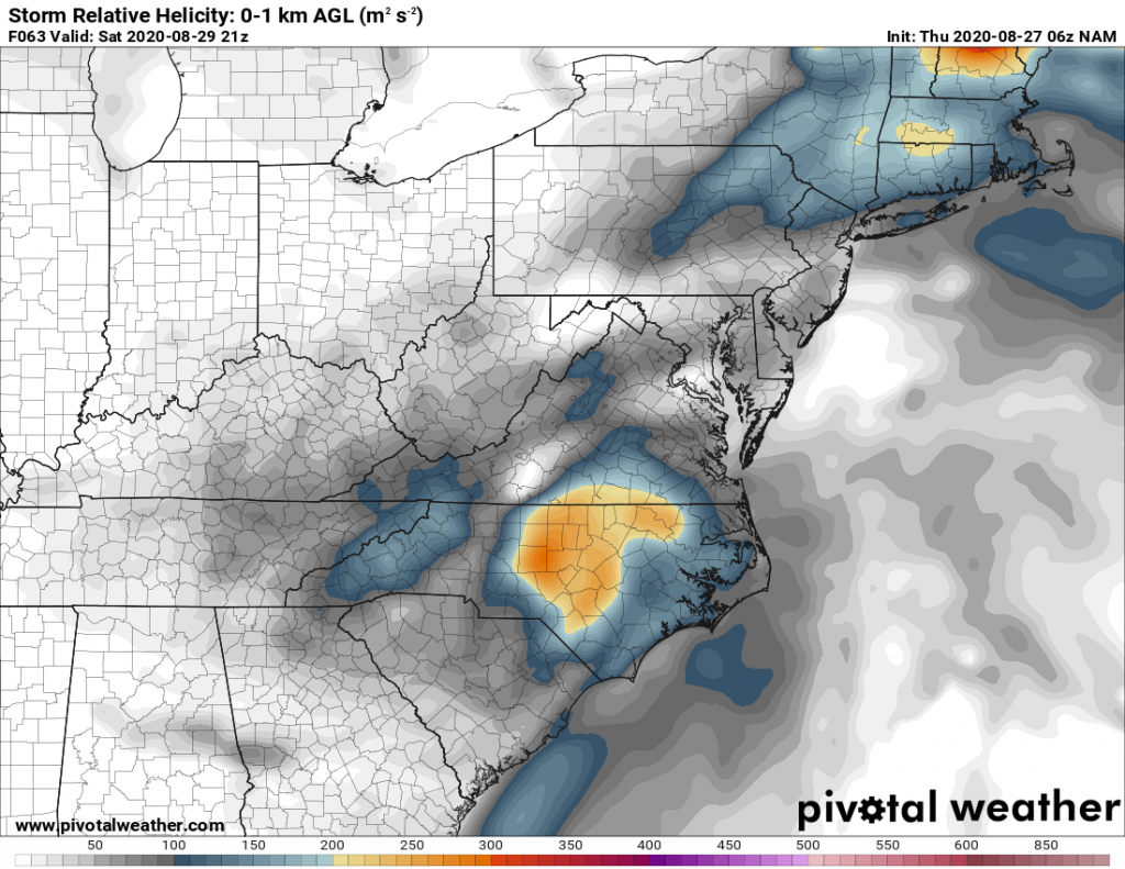
Heavy rain is not expected to be widespread across the mid-Atlantic on Saturday, as any flash flooding looks to be mainly confined to the higher terrain of Kentucky, western Virginia, and southern West Virginia. But locally heavy thunderstorms remain possible across our region.
And finally, we need to watch the tropics again as more storms (Nana, Omar, Paulette, etc.) are expected in the next few weeks. The MJO phase which favors western Gulf and eastern Pacific storms does shift east and allow for more potential threats to the East Coast, the southwest Atlantic, and the Caribbean and southern Gulf in the coming weeks. September could be very active, and the Carolinas should be on guard. Weary residents in the Gulf should also remain steadfast.
-CWA
You must be logged in to post a comment.