Skip to content
Latest
  • Single Digits Likely Tonight in the Carolinas
  • Final Call for Carolina Late-January Ice Storm
  • Artic Cold Set to Grip the Region Before Late Month
  • Cold End to 2025; Sneak Peek at January
  • Arctic Temperatures Expected Sunday Into Monday
Carolina Weather Authority

Carolina Weather Authority

  • Home
  • Map Wall
  • Home
  • Hurricane Season
  • Page 23

Category: Hurricane Season

Invest 94L is Born

July 2, 2017 By Michael Griffith

We now have Invest 94L in the Atlantic. Chances of development are 60% over the next 5 days by the NHC. Fortunately, models are takingRead More

Share to inform your family and friends!

  • Tweet
  • Email a link to a friend (Opens in new window) Email

Like this:

Like Loading…

NHC and Models Continue to Indicate Tropical Trouble

July 2, 2017 By Michael Griffith

The NHC has now increased their probability to 50% of formation with the tropical wave currently in the Atlantic. This wave is forecast to continueRead More

Share to inform your family and friends!

  • Tweet
  • Email a link to a friend (Opens in new window) Email

Like this:

Like Loading…

GFS and GEFS Indicating Trouble in the Tropics

June 30, 2017 By Michael Griffith

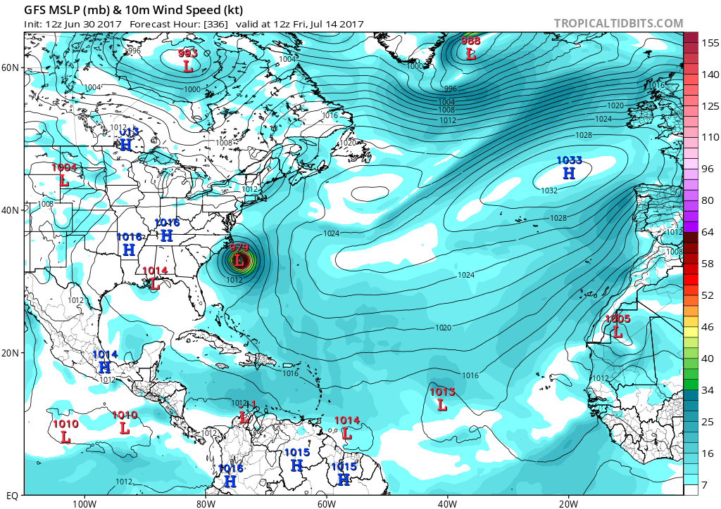
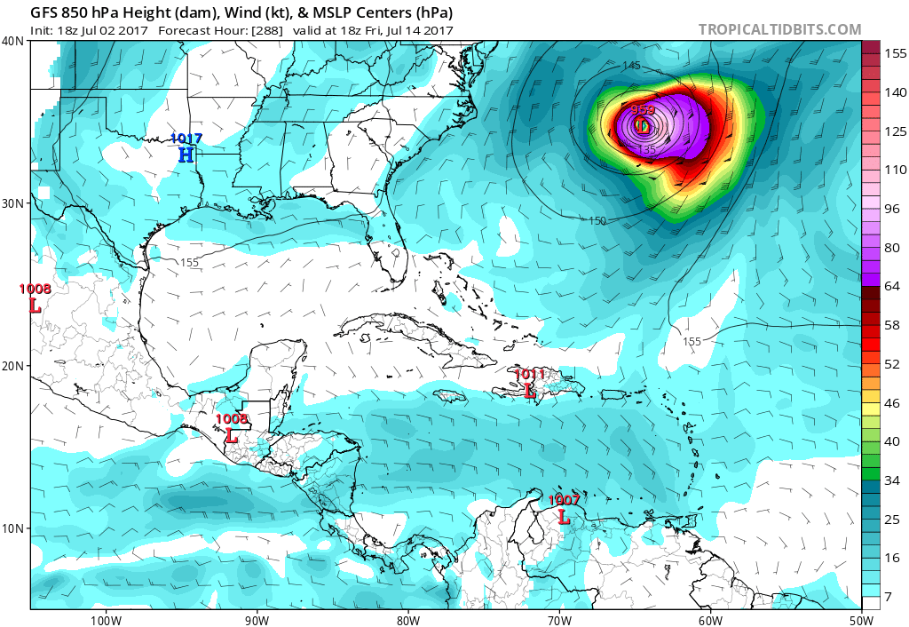
Hurricane season is in full swing, and you should have a plan of action should the need arise. We are looking at the GFS, whichRead More

Share to inform your family and friends!

  • Tweet
  • Email a link to a friend (Opens in new window) Email

Like this:

Like Loading…

Wet Weekend Ahead as the Remnants of Cindy Curve Across the Eastern US

June 22, 2017 By Michael Griffith

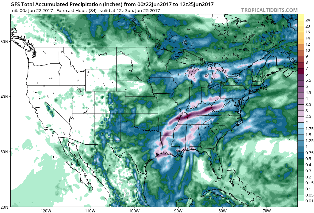
Total rain amounts from the GFS are highest to the west of the mountains, however once she takes a turn to the East, the mountainsRead More

Share to inform your family and friends!

  • Tweet
  • Email a link to a friend (Opens in new window) Email

Like this:

Like Loading…

Tropical Storm Cindy To Make Landfall Late Wednesday/Early Thursday

June 21, 2017 By Michael Griffith

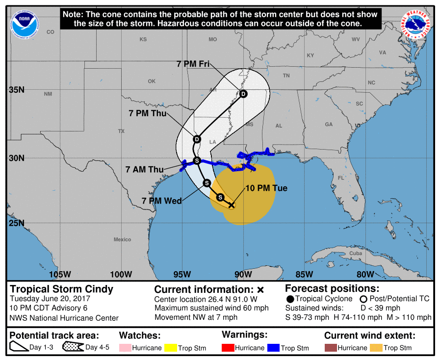
Tropical Storm Cindy will be more of a nuisance than anything. Not so much in the way of wind, but with the rains and flooding.Read More

Share to inform your family and friends!

  • Tweet
  • Email a link to a friend (Opens in new window) Email

Like this:

Like Loading…

Comparison of Models for Invest 93L, Where the Storm is Likely Headed

June 18, 2017 By Michael Griffith

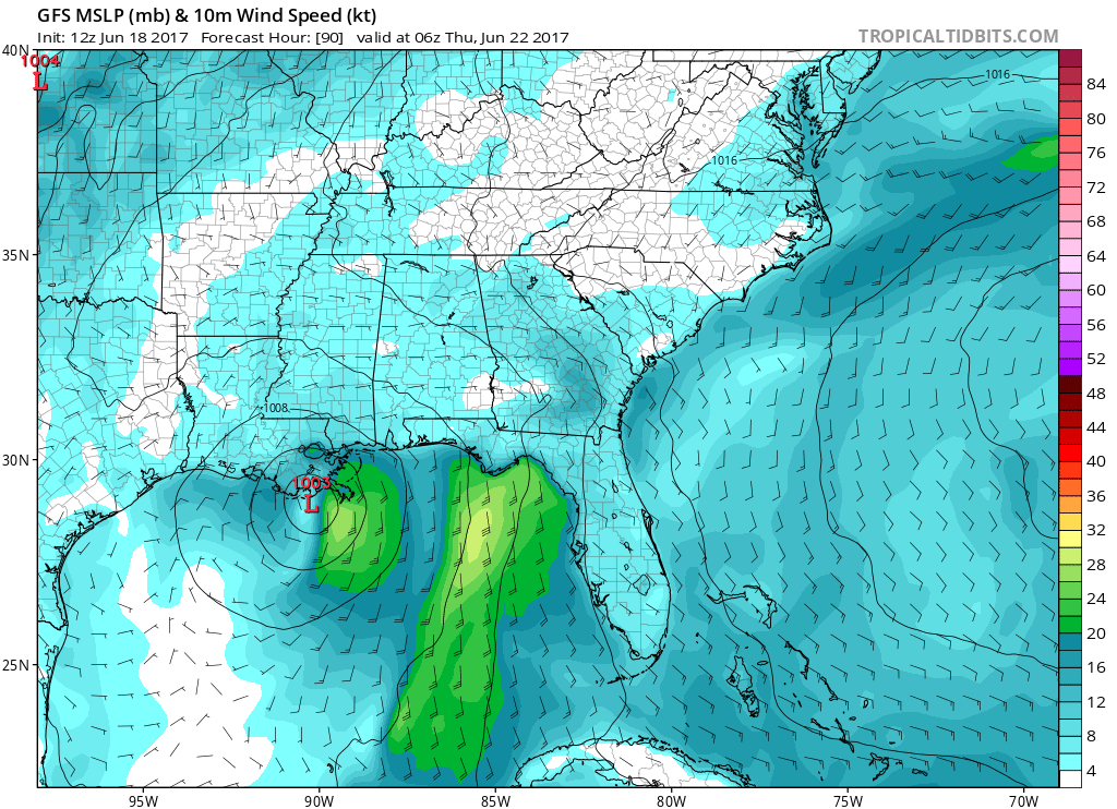
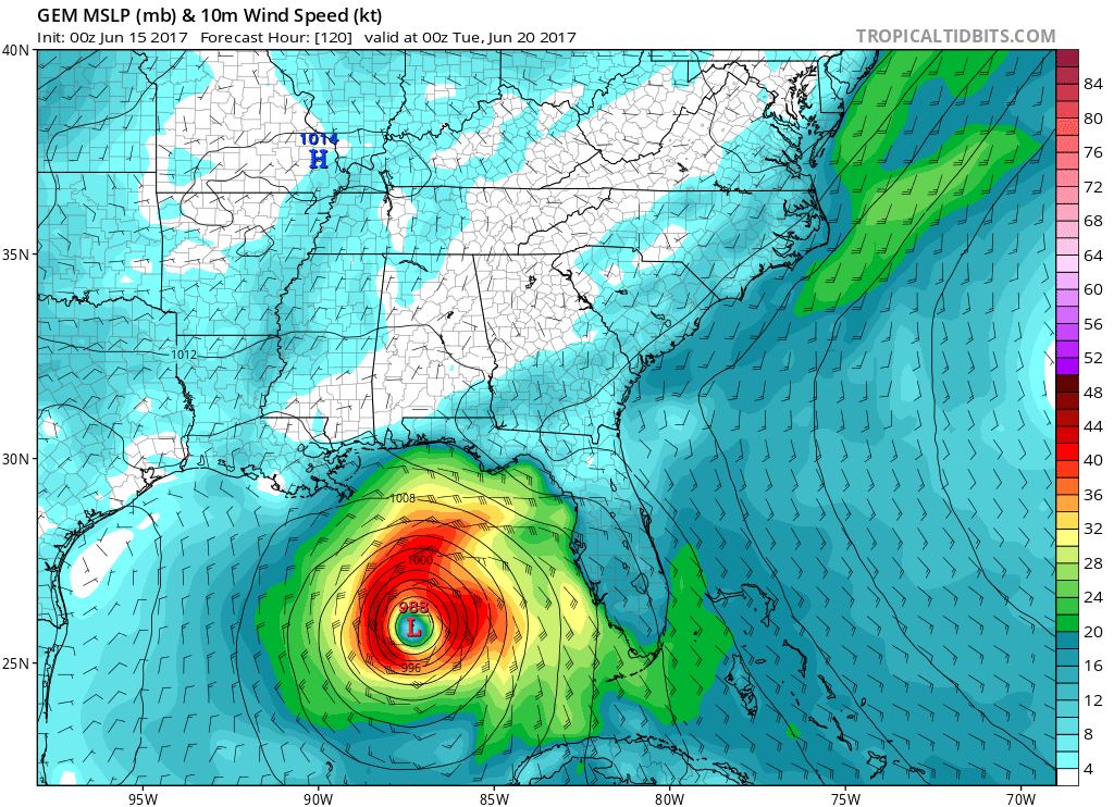
Which model will end up being right? The GFS? CMC? Euro? No one knows for sure, and this system could make landfall anywhere in theRead More

Share to inform your family and friends!

  • Tweet
  • Email a link to a friend (Opens in new window) Email

Like this:

Like Loading…

Typical June Tropical Cyclone Tracks

June 16, 2017 By Michael Griffith

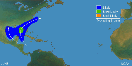
TYPICAL JUNE TROPICAL TRACKS A little bit of weather education….typical June tracks for tropical cyclones. We can use these as analogs to help us determineRead More

Share to inform your family and friends!

  • Tweet
  • Email a link to a friend (Opens in new window) Email

Like this:

Like Loading…

Disturbance in South Atlantic has 40% Chance of Formation

June 16, 2017 By Michael Griffith

I’m not worried about the disturbance in the Guld, which will likely just drift into Eastern Mexico as a tropical depression, but I’m more worriedRead More

Share to inform your family and friends!

  • Tweet
  • Email a link to a friend (Opens in new window) Email

Like this:

Like Loading…

Tropical Depression Could Be Headed to South Texas

June 15, 2017 By Michael Griffith

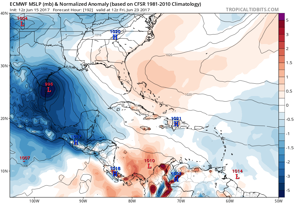
The lastet run of the Euro takes the tropical feature from the coast of the Yucatan Peninsula to the southern tip of texas. This isRead More

Share to inform your family and friends!

  • Tweet
  • Email a link to a friend (Opens in new window) Email

Like this:

Like Loading…

Keeping an Eye on the Gulf of Mexico

June 15, 2017 By Michael Griffith

The latest talk has been about a disturbance in the Gulf of Mexico. The question is what will this disturbance turn into and which wayRead More

Share to inform your family and friends!

  • Tweet
  • Email a link to a friend (Opens in new window) Email

Like this:

Like Loading…

Posts navigation

Older posts
Newer posts

Like us on Facebook!

Like us on Facebook!

Active Alerts

Current NWS Watches, Warnings, and Advisories

7-Day Tropical Outlook

Today’s Severe Threat

Follow Us

  • Facebook
  • X
  • Instagram
  • YouTube
© 2019 Best blog in 21st Century
Powered by WordPress - Lekh by ThemeCentury
Carolina Weather Authority

Loading Comments...

You must be logged in to post a comment.

    %d